Walk 2228 - printer friendly version
Romaldkirk Moor Walk
Author - Lou Johnson
Length - 7.6 miles / 12.4 km
Ascent - 700 feet / 212 metres
Grade - easy/mod
Start - OS grid reference NY968233
Lat 54.604859 + Long -2.0510530
Postcode DL12 0JN (approx. location only)
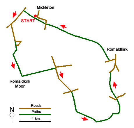
The start of this walk is the small car park and picnic area to the south of Mickleton village (grid ref. NY968233) which is located beside the old railway line that once ran along this part of Teesdale. After parking walk northwest (with the village of Mickleton to your right) and continue along the trackbed of the old railway for about 500 metres to the first overbridge. Here leave the old railway and ascend to the lane. Turn left (southwest) and continue for just over half a kilometre to a road junction (grid ref. NY960232).
Turn left here and follow the gently rising lane south. Where the lane turns sharp left, continue ahead on the footpath taking a short cut across a field to re-join the lane at Swarthy Mere. Here head south following a clear track with a wall on your right. Continue with the wall on your right when the wall turns right (grid ref. NY961223) until reach a wall corner after a further 200 yards. From this point the right of way heads roughly south across rough pasture. The path is not clear on the ground and you will need to make your own way just east of south towards a gate in a cross wall (grid ref. NY962218). Go through the gate and with the wall on your right to reach a track (grid ref. NY963214).
Turn left along the track to a crossroads (grid ref. NY974217). Turn right here following a tarmac lane that descends past Currick Rigg on your left to a road junction (grid ref. NY980210). Turn right and then almost immediately left to join the access drive leading south to Gill Field Farm (grid ref. NY981203). Follow the path through the farmyard, over a stile, through a small gate and then over another stile to enter a large field. Aim half left across this field (roughly south-east), through a gate and continue in the same direction down to West End Farm. Here waymarks lead you through the farm and onto the access drive. After just over 600 metres by a small stream go through a waymarked gate on your right. Cross the field to reach an access gate to the Teesdale Railway Path. Turn left and follow the easy graded path to reach a lane and the end of the railway path (grid ref. NY992216).
Turn right along the lane into Romaldskirk village. Bear left along the B6277 at the first junction and continue into the centre of the village. Reaching a road junction, turn left along a lane. This leads to the continuation of the Teesdale Railway Path which is accessed on your right. Follow the clear path and continue for just under two miles to reach the small car park where the walk started.
Messaging & Social Media
Message Walking Britain and follow the latest news.

Mountain Weather
Stay safe on the mountains with detailed weather forecasts - for iOS devices or for Android devices.