Walk 2237 - printer friendly version
Somerleyton & Herringfleet Hills Walk
Author - Lou Johnson
Length - 3.5 miles / 5.7 km
Ascent - 100 feet / 30 metres
Grade - easy
Start - OS grid reference TM478971
Lat 52.5154020 + Long 1.6507729
Postcode NR32 5QX (approx. location only)
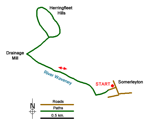
This short walk in The Norfolk Broads provides a pleasant couple of hours alongside the River Waveney. The highlight of the route is for many the lovely Herringfleet Drainage Mill. The route also includes the Herringbone Hills. However, do not expect these to be too challenging as the highest point is only 80 feet above sea level!
The start of the walk is the village of Somerleyton (grid ref. TM478971). The village lies a few miles south-west of Great Yarmouth just off the B1074 south of St Olaves. Parking is restricted and the Duke's Head will, I am sure, allow parking if you are a customer. After parking make your way down the lane to the Marina and the River Waveney. Turn right along the banks of the River and continue north for a kilometre to reach the Herringfleet Drainage Mill.
Turn right away from the river and follow the path into the Herringfleet Hills, which are as the name suggests some of the highest land in the vicinity. Reaching only 80 feet above sea level you are unlikely to meet any steep paths so just relax and enjoy the view. The return follows the outward route.
Messaging & Social Media
Message Walking Britain and follow the latest news.

Mountain Weather
Stay safe on the mountains with detailed weather forecasts - for iOS devices or for Android devices.