Walk 2270 - printer friendly version
Tilberthwaite and Holme Fell Little Langdale Walk
Author - Lou Johnson
Length - 5.5 miles / 8.9 km
Ascent - 1300 feet / 394 metres
Grade - easy/mod
Start - OS grid reference NY316034
Lat 54.421416 + Long -3.0556567
Postcode LA22 9NZ (approx. location only)
Despite their modest height, the low Lakeland fells lying to the east of Wetherlam provide interesting walking. This Lake District walk takes in some of the highlights and will perhaps encourage you return and explore the area in greater detail.
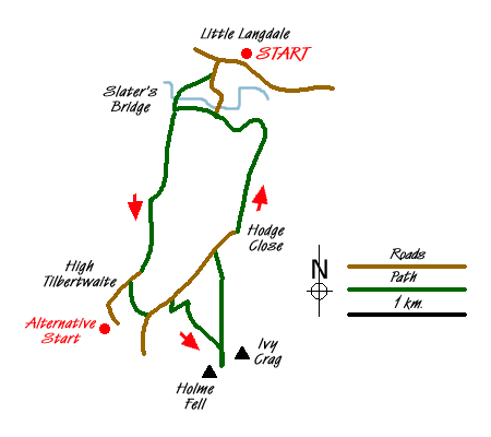
The start for this walk was the Three Shires Inn in Little Langdale (Grid ref. NY316034) after an overnight stay. However if you are not a resident than permission needs to obtained prior to parking or alternatively you can use the very limited on road parking near the hotel or park at Tilberthwaite (Grid ref. NY306009) and make suitable adjustments to the route. Exit the hotel and turn right. Take the lane on the left. After short way down the lane, take the footpath on your right. This leads across a field down to the very picturesque Slater's Bridge. Cross the bridge to reach a lane. Go a few metres to your left and then right onto a narrow quarry track. This leads you into a field where you ascend with the wall on your left. Reaching the brow of the hill the path joins a track. Turn left (south) along this track to High Tilberthwaite where you join a lane.
Almost immediately after the farm buildings, take the signed footpath on your left (Grid ref. NY307013). This crosses two fields and passes through Low Coppice to reach a tarmac lane. Turn left along this lane as far as Holme Ground. Go through the gate opposite and follow the track with a wall on its left-hand side. Just past the water tank turn sharp left and follow the bridleway to another gate (Grid ref NY312011). Go through the gate and take the first path on your right. This leads uphill soon providing you with a view ahead to Holme Fell on the right and Ivy Crag to its left.
The terrain in the vicinity can be confusing so do take time to read your map and cross check the detail with the view ahead. Continue along the path gaining height towards the col between the two minor summits. The path drops down a little from where you take the short path on the right to the summit of Holme Fell. There is a short section of rock to overcome but this is easily overcome and you are soon on the summit enjoying the view. From this vantage point you need to make a mental note the paths in relation to the two small tarns/reservoirs below. After completing an ascent of Ivy Crag you will be taking the path to the right of the two tarns.
Return to the col and go straight ahead and follow the cairned path to the summit of Ivy Crag. The panorama is probably better than from Holme Fell with many of Lakeland's major fells featuring in the grand panorama. Satisfied you have spent enough time on the summit retrace your steps to the col and start to descend on the path used for the ascent. You should have worked out the layout of the paths when on Holme Fell so locate the junction and bear right to descend past the tarns/reservoirs keeping them on your left.
Once past the tarns the path improves and you continue downhill past a small quarry to join a track by a wall. Turn right and follow the track downhill. Go through the gates but beware that there is a significant drop into Hodge Close Quarry on the right hand side. If you have small children or dogs then ensure they are strictly supervised on this section. The onward route keeps the quarry on your right and leads you to a road. Turn right (north) towards Hodge Close.
Continue along the track until reaching a gate in a wall (Grid ref NY318022). Do not follow the track as it bears left but follow the path going straight ahead. This passes to the left of the boggy area named 'the Dubs' on OS maps to reach drier ground and a gentle descent into Little Langdale. Turn left onto the track and follow it past Stang End to reach the path junction at grid ref. NY315028.
Continue along the south side of the River Brathay. A short way along on your left is a small path leading into a tunnel. Usually there is water under foot so do be careful. This leads you into one of the old slate workings called "Cathedral Cavern". Further exploration should not be attempted and after admiring the handiwork of the quarrymen, return to the lane. Turn left up the lane and take the first footpath on the right. This leads across Slater's Bridge and all you need to do is follow the outward route back to the car.
Messaging & Social Media
Message Walking Britain and follow the latest news.

Mountain Weather
Stay safe on the mountains with detailed weather forecasts - for iOS devices or for Android devices.