Walk 2457 - printer friendly version
Stanborough Park, Welwyn Garden City Walk
Author - Barry Mackie
Length - 2.0 miles / 3.3 km
Ascent - 70 feet / 21 metres
Grade - easy
Start - OS grid reference TL227111
Lat 51.785115 + Long -0.22257985
Postcode AL8 7TB (approx. location only)
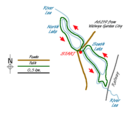
This short Hertfordshire walk is a superb way to spend a couple of hours and, whilst very close to Welwyn Garden City, you get that countryside feel and a chance to spot some of the many varieties of birds that visit the park. The footpaths around the two lakes are in excellent condition and are ideal for families with pushchairs.
Set in 129 acres and bisected by the A6129 road, Stanborough Park has plenty to offer for outdoor activities such as rowing on the northern lake and fishing and sailing on the southern lake. There is an information centre, toilets, an undercover café and a restaurant, all next to the southern lake.
If you are travelling by car, then follow the A6219 Southwest out of WGC and take the left slip road (grid ref TL227111) down the short slope to reach the large car park near the southern lake. Note; alternatively if you approach from the other direction, there is also a car park near the northern lake. Whichever way you travel though, it is left turn only from the main road. This walk is described from the southern car park, but is easily interpreted from the northern car park. If you plan to travel by public transport, then Welwyn Garden City has a railway station in its town centre and regular bus services pass the park on the A6219.
Cross the River Lea, Hertfordshire's largest river, by the wide wooden bridge next to the restaurant and turn right onto the path between the river and the lake. Here there is an excellent information board portraying some of the many species of birds to be seen on and around the lakes. Follow this path between the lake and river, until you reach the bend in the river (grid ref TL230 106) and the start of Stanborough Reedmarsh Nature Reserve.
The path through the nature reserve can be difficult when wet and isn't suitable for push chairs, so you can simply continue along the main path around the lake, and ignore the next section of this description. Follow the unmade path alongside the river, through the nature reserve, until it turns sharply to the left as you approach the railway viaduct. Take this path, as to follow the river under the viaduct leads to private property and no access. Soon you reach a slightly raised wooden bridge to lead out onto open parkland, where you veer left to return to the path by the lake.
Continue alongside the lake and then round the perimeter fence of the boatyard to reach the café and information centre, and a few steps further, the path next to the river. Turn right here, and with the river to your left, go under the low A6219 road bridge to the wooden footbridge over the river. Cross here and turn right and with the river on your right, start your walk around the northern lake.
A few yards before the end of the lake, there is a long wooden bridge which can be a shortcut to the path on the far side, if you wanted. Be careful though, it can be quite slippery when wet. At the far end of the lake, stay on the path around the lake, leaving the line of the river, and head back to the road bridge. Retrace your path back under this bridge to reach the information centre and café, which is where this walk ends.
Messaging & Social Media
Message Walking Britain and follow the latest news.

Mountain Weather
Stay safe on the mountains with detailed weather forecasts - for iOS devices or for Android devices.