Walk 2510 - printer friendly version
Totridge Fell via Langden & Bleadale Water Walk
Author - Paul Heap
Length - 10.0 miles / 16.3 km
Ascent - 1270 feet / 385 metres
Grade - mod/hard
Start - OS grid reference SD661501
Lat 53.945886 + Long -2.5179707
Postcode BB7 3BB (approx. location only)
The Forest of Bowland is one of Lancashire's best kept secrets. With a wonderful mixture of wild and cultivated scenery this walk explores some of the unique character of this Area of Outstanding natural Beauty. As with all moorland and high level excursions this walk should not be attempted by inexperienced walkers in poor weather conditions as leaving Bleadale Water can be disorientating in poor visibility.
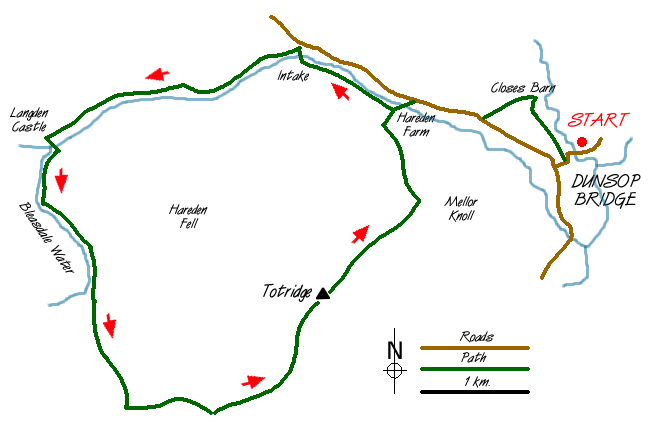
The walk begins from the car park at Dunsop Bridge (Grid ref. SD661501). Leave car park and cross the bridge turning right after the bridge to follow the road past a group of houses. Eventually this becomes a path which continues towards Closes Barn where care needs to be taken as the path seems to be hidden by rubbish and small green houses! Head left towards the wall and you will see a rusting gate. Go through this gate and follow the path across the field down to the road coming out near a cattle grid. Turn right and follow the road for a short distance to Hareden Farm. Cross over the bridge and turn right to see the stile. This path now goes alongside Langden Brook towards the Intake passing Smelt Mill, which is the home to Bowland Pennine Mountain Rescue Team.
Crossing a small footbridge at the Intake follow the path up the valley alongside Langden brook towards Langden Castle (Grid ref. 606503). This is not a castle but a stone hut and its origin is not fully known although some locals have suggested that it was a stop over for guards and prisoners on their way to Lancaster assizes.
From here, the path goes below Sykes Fell into the valley containing Bleadale water. Care should be taken from here, especially in poor visibility. After crossing the brook, which can be difficult in spate, keep to the left-hand side of the valley where a narrow path climbs steadily alongside the stream. Allow plenty of time ascending Bleadale water as it will take much longer than you think. The path gradually rises until you reach the head of Bleadale water near to a small waterfall. Unfortunately from here the path disappears and you need to keep heading due south taking care underfoot because of the hidden holes and the density of the heather. Eventually you will see the fence line, which in bad weather is a welcome sight.
Follow the fence line easterly towards Totridge Fell. Again allow plenty of time as the terrain can be difficult in places. Pass the grouse butts (Grid ref. 624475) shortly after which the fence turns into a wall. Keep the wall to the right hand side for quite some distance and you will eventually come close to the summit of Totridge Fell. To visit the summit you will need to leave the wall and head north east for approximately 100 yards until you reach the actual summit. From here there are some magnificent views of Lancashire and the neighbouring counties.
Leaving Totridge you descend steeply down following the wall until you pick up the main path north west of Mellor Knoll (Grid ref. 644497). Head left towards Hareden Farm and from here it is a simple return to the car park at Dunsop Bridge using the first section of the outward route or alternatively staying with the road.
Messaging & Social Media
Message Walking Britain and follow the latest news.

Mountain Weather
Stay safe on the mountains with detailed weather forecasts - for iOS devices or for Android devices.