Walk 2515 - printer friendly version
The River Derwent, Curbar, Baslow & Froggatt Edges Walk
Author - Mike Bexley
Length - 7.5 miles / 12.2 km
Ascent - 890 feet / 270 metres
Grade - easy/mod
Start - OS grid reference SK255777
Lat 53.295649 + Long -1.6188816
Postcode S32 2HX (approx. location only)
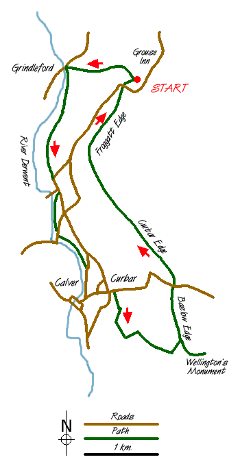
A Peak District walk for any season. Starting in woodland, it follows the deeper stretches of the River Derwent returning to high ground to look down on the river with spectacular views over the Chatsworth Estate and the village of Eyam. The start is a small car park (grid ref. SK255777) at Hay Wood off the B6054 near the Grouse Inn. Another walk of totally different character starts from this same car park - walk 2520. The unmarked lane entrance to the car park is on the road north of Froggatt village, just prior to 'The Grouse Inn'. From the car park head downhill through the woods in a westerly direction taking the steeper left path at the fork. Follow this down through the woods and lanes to reach the River Derwent at a road bridge (grid ref. 245778).
Do not cross over the bridge but take the path left just before the bridge. Cross the field diagonally towards the woods in the left corner of the field. Continue to follow a clear path through the woods leading to Spooner Lane and then Froggatt village (grid ref. 243763). Keep straight on to the river, do not cross over instead taking the path that starts with a narrow gap in the wall entrance to the left of the river.
This path follows the river and on reaching the road cross over to continue this lovely riverside stroll until it ends at another road. Continue on the road in the same direction to Calver (grid ref. 247744). The large Mill building across the river on you right was the 'prison' in the television series 'Colditz'.
At the road junction turn left up the hill (this is a steep pull) and at the cross roads with its telephone box turn right to take the narrow footpath on the left through the wall between houses. On reaching a lane turn right. At the end of the lane (grid ref. 252741) head uphill keeping to the right of the large trees following the path to the second wall. On reaching this point turn sharp left and follow the wall to reach the entrance into a small wood. Go through the wood and up on to a very wide path. Turn right and follow this path uphill, keeping to the left of the wall (do not go through the gate) and through a small quarry to the top path bearing left.
To the right of you is Wellington's Monument, well worth the visit for the views over Chatsworth. It is said, but not proved, that it was built to commemorate Wellington's visit to this area. Not to be out-done opposite you on the distant southeast ridge, there is a another monument, to Nelson, built five years after his battle at Trafalgar.
Return to the path by cutting across the moor to the very large stone named Eagle Stone (grid ref. 262740). Legend has it that the young men of Baslow proved how fit they were for marriage by climbing to the top. There certainly were a lot of marriages but it was thought due to them finding an easy way up! The path now heads North at first along Baslow Edge to dip down to cross a road before continuing along Curbar Edge. All the time you have wonderful views on your left and flat moors on your right. It finishes through some trees at a road where you cross over down to a small stream and up the other side to the car park.
Mike has led 'Mike's Hikes' for the last 4 - 5 years, since leaving Mountain Rescue where he was based in Hayfield as part of the Kinder MRT. E-mail "Mike's Hikes"
Messaging & Social Media
Message Walking Britain and follow the latest news.

Mountain Weather
Stay safe on the mountains with detailed weather forecasts - for iOS devices or for Android devices.