Walk 2520 - printer friendly version
Higger Tor & the Longshaw Estate Walk
Author - Mike Bexley
Length - 9.0 miles / 14.6 km
Ascent - 1300 feet / 394 metres
Grade - moderate
Start - OS grid reference SK255777
Lat 53.295649 + Long -1.6188816
Postcode S32 2HX (approx. location only)
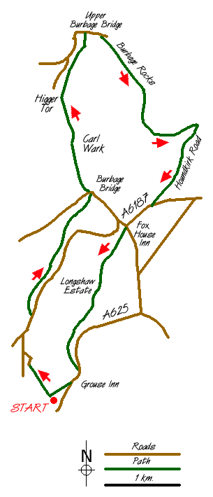
This Peak District walk starts from the same car park as walk 2515 but provides a contrast in terrain leaving the picture post card villages for the wilder moorlands, cliffs and valleys. Start from the small car park (grid ref. 256778) at Hay Wood located on the road north of Froggatt village just prior to 'The Grouse Inn'. From the car park head west downhill through the woods. Do not take the left steeper path but continue straight on heading north. The path comes out of the woods to follow a lane down to a road (grid ref 252786).
Cross over the road turning right to take the footpath into the woods on your left. Follow this path but look out for a footbridge to your left down a steep bank, which crosses 'Burbage Brook'. After crossing the footbridge, climb up the other side to take the footpath right. This follows the brook upstream to the main Sheffield - Hathersage Road (grid ref 262807). Just before reaching the main road you cross another footbridge. The footpath climbs to the right up to a gate at the road. Go through the gate and turn left along the road towards Hathersage.
Cross over the 'Burbage Bridge' at the corner and take the stile on the opposite side of the road. Climb up the short bank then follow the footpath right. This path starts off well but becomes fainter later on however you should head for left side of Carl Wark (grid ref. 259815) with Higger Tor lying behind it in the distance.
Carl Wark is reputed to be an iron-age hill-fort. It is a natural plateau with stone wall fortifications, made up of large blocks of gritstone. If you walk around the south edge you will see entrances set into the stone wall. There is also a detailed plaque at the south west corner and a water trough carved out of stone.
From your explorations on Carl Wark you will have seen your next footpath north to Higger Tor (grid ref. 257819). Having reached there it takes a bit of an effort to get to the top but that is soon forgotten when you see the views. Descend again and follow the path north, called Fiddler's Elbow, which contours the hill before reaching Upper Burbage Bridge (grid ref. 261830)
Cross over Burbage Brook and take the higher path heading south. This is a good path that follows the rim of Burbage Rocks and you should stay on this path until you meet the footpath coming up from woods near Carl Wark (grid ref. 271814). Turn left here. The footpath now goes over Burbage Moor but look out for a path to your right (grid ref 274815) that leads to a bridleway called Houndkirk Road. Turn right (southwest) and follow this old road to the main road, which is followed in the same direction to a road junction at 'Fox House Inn'.
At this road junction turn left and proceed up the road to turn right through the gates into Longshaw Estate (National Trust). This rocky moorland estate with its tree plantations, inspired Charlotte Brontë's "Whitecross", Jane Eyre got off the coach at the Inn you are to pass soon. Follow the drive towards the hall then take the path that passes in front of the café/shop, through a gate heading south. This path joins the main drive to the hall from the road. How impressive it must have been to the guests in their horse drawn coaches. Keep on this drive to reach the main road, turning right to pass the 'Grouse Inn' (grid ref. 258779). Then take the footpath right at the end of their car park, which diagonally crosses the fields to take you back to where you started.
Messaging & Social Media
Message Walking Britain and follow the latest news.

Mountain Weather
Stay safe on the mountains with detailed weather forecasts - for iOS devices or for Android devices.