Walk 2526 - printer friendly version
Standing Crag, Ullscarf & Borrowdale Walk
Author - Mike Bexley
Length - 10.0 miles / 16.3 km
Ascent - 2600 feet / 788 metres
Grade - mod/hard
Start - OS grid reference NY276163
Lat 54.536771 + Long -3.120455
Postcode CA12 5UW (approx. location only)
This Lake District walk can be challenging as it covers open fells with waterfalls adding wet conditions to the route. In bad weather, good boots, waterproof clothing, map and compass are essential. As a bonus you are in the centre of the Lake District National Park with 360 degree unrestricted views of the fells and mountains - the mass of Helvellyn to the east, Fleetwith Pike and Red Pike to the west, Coniston Old Man to the south but the best views are north to Skiddaw and Blencathra.
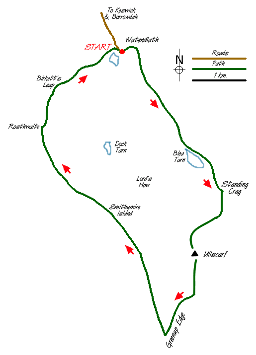
The walk starts from the lovely, peaceful National Trust Hamlet of Watendlath (grid ref 276163) situated at the end of a single track lane, off the B5289 Keswick to Borrowdale road. At first proceed in an easterly direction from the car park climbing part way up the hill before taking the first path on the right, keeping on the left hand side of the wall.
The footpath is very good at first but can be extremely wet on reaching the remote Blea Tarn (grid ref 290143). Meaning 'Blue Tarn' it is in an very impressive location flanked on one side with the cliffs of Low Saddle. Follow the wet footpath to the left (east) of the tarn. Go over the stile at the boundary fence then turn right to follow a path that climbs steeply through a gully to the left of the imposing Standing Crag.
This path (not indicated on all maps) swings right after the gully near the top to meet the boundary fence behind Standing Crag. Follow the well-worn path with the fence on your right until you reach the corner of the fence where the fence turns sharp right. Keep straight on following the boundary posts gradually climbing up to the cairn on Ullscarf (grid ref 292121). After enjoying the view continue to follow the boundary posts proceeding to Greenup Edge (grid ref 286105).
At this point turn right down the good path that descends steeply to Smithymire Island. The path follows Greenup Gill and depending on recent rainfall, can be full of challenges as you cross through the waterfalls. On reaching Smithymire Island (grid ref 275130) follow the path north west alongside the beautiful Stonethwaite Beck to the outskirts of Rosthwaite. Cross over the river bridge (grid ref 259150) then its straight-on to follow the very wide path that climbs up steeply north and later north-west via Birkett's Leap (grid ref 264157) and Puddingstone Bank before dropping down to the packhorse bridge at Watendlath and your start.
Messaging & Social Media
Message Walking Britain and follow the latest news.

Mountain Weather
Stay safe on the mountains with detailed weather forecasts - for iOS devices or for Android devices.