Walk 2528 - printer friendly version
Kettleshulme & Sponds Hill Walk
Author - Mike Bexley
Length - 8.0 miles / 13 km
Ascent - 1600 feet / 485 metres
Grade - moderate
Start - OS grid reference SJ956795
Lat 53.312417 + Long -2.0675007
Postcode SK10 5RX (approx. location only)
The Cheshire sector of the Peak District National Park is often discounted as being uninteresting although this route does much to dispel the common stereotype. It is worth noting that this walk has a couple of long steep ascents towards the end but your efforts are well rewarded by views and interesting changes of landscape. After periods of heavy rain, conditions underfoot can be very wet so good footwear is essential.
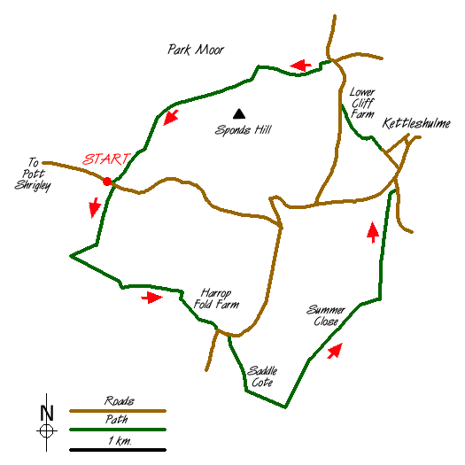
This Peak District walk starts from a small parking space on the road from Pott Shrigley to Kettleshulme (grid Ref SJ956795) marked as 'Bakestonedale Road' on the 1:25000 OS Map. Locate the footpath leaving this road (grid ref. SJ956795) and cross the stile and head south climbing up the field with the wall on your right. Keep straight on to the gate. Turn right down to the farm track then left along this track, which ends at a private car park serving some cottages.
Cross over the stile in the wall and drop down to a footbridge over a brook. Turn sharp left before the second bridge walking up the field. Look out for an overgrown green lane on your right. These old lanes are similar to wide ditches sunk between walls or high hedged banks and this walk uses a few of them. The lane is very overgrown at first but later opens-up with views on the left down to Black Brook and Harrop Wood.
Keep on this lane through gates until the last gate (grid ref 964783), which has a path sign to the right. On reaching the farm track turn left to Harrop Fold Farm. Continue through the farm. At the road turn left then right through a farm gate signed "Never mind the dog beware of the owner". Keep on this farm track keeping to the left of the farm and outbuildings and passing through a couple of gates. The path now descends left to the bottom of a ditch and over a stile to reach Moss Brook (970773). Walk up the hill opposite towards Saddle Cote. At the wide gap in the wall turn left. Keeping the wall on your right walk up the hill until you reach another wall and path junction.
Turn left with this wall on your right to a stile. Descend down the path that follows the broken wall to a small gate at Summer Close (grid ref 980778). Go through the gate opposite, keeping to the wide path ahead turning right behind the 'chicken coop' to the bridge over Todd Brook. Climb up the short bank. Then, walking in the same direction, you will see the path leading to a stile. Keep straight following the line of trees on your right to another stile leading down to ford across a small brook.
Proceed uphill to the deserted farm ahead (grid ref. 986783). Continue through the yard and over the stile in the wall. Turn left to follow the fences over stiles and through a farm gate to a lane that passes Thorneycroft Farm. On reaching the lane (Side End Lane) turn left in the direction of Kettleshulme. Reaching the B5470 turn right into Kettleshulme. Turn left down Paddock Lane to the bottom (grid ref 986799). Take the footpath between the houses walking straight on to a footbridge over the brook. Then it is a steep pull up the field to the fence.
Go through the two gates to the right of the sheep pen, which leads you to the road at Lower Cliff Farm (grid ref 982804). Turn right down the road passing Handley Fold Farm and turn left at the first stile and path sign. This path leads you to another good example of a green lane. One can picture ponies using these lanes over the hills transporting goods - Pickfords were based at Bollington and their business started in such a way.
The lane climbs up to the ridge (grid ref 972808) to join a bridleway. Turn left to the end of the wall then right to follow the perimeter wall of Lyme Park. Look out for the herds of deer on the other side of this wall. The grassy restful path branches left away from the wall gradually descending to a stile over a wall then to your start, which is not apparent until you reach the gate.
Messaging & Social Media
Message Walking Britain and follow the latest news.

Mountain Weather
Stay safe on the mountains with detailed weather forecasts - for iOS devices or for Android devices.