Walk 2546 - printer friendly version
Lantern Pike & Cown Edge from Rowarth Walk
Author - Mike Bexley
Length - 8.0 miles / 13 km
Ascent - 1300 feet / 394 metres
Grade - easy/mod
Start - OS grid reference SK011892
Lat 53.399625 + Long -1.9849213
Postcode SK22 1EF (approx. location only)
This area is just inside the far western boundary of the Peak District National Park and is often ignored by walkers as the greater attraction of the Kinder Plateau is so close. However undertake this lower level walk and you will be surprised at the variety of views and countryside.
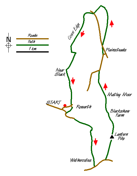
This Peak District walk starts from the car park in Rowarth (Grid ref. SK011892). The approach to this car park is from Hollinsmoor Road. Walk towards the houses then follow the road to the right, at the bottom take the footpath on the right down to 'The Little Mill' public house with its water wheel (grid ref 011890). Walk past the pub and follow the road until you come to a junction. Continue straight and go along the bridleway, you will come to a junction, continue straight until you go through Wethercoates Farm (grid ref 020872) and then reach the road.
Turn left along this road then left again up the lane towards Lantern Pike. You can follow the wall straight on but to really gain the full benefit of the views of Kinder follow the worn footpath on the left to the top. As the name suggests fires were lit here to warn of danger or to commemorate events. The hill also has a direction information plaque.
Leave the summit on the path heading north to rejoin the main path. Continue in the same direction across the fields to reach the footpath junction above Blackshaw Farm (Grid ref. 025889). Still heading north follow the footpaths and bridleways passing Matleymoor Farm to reach the corner of the road (Grid ref. 022904). Turn right and follow the road until the next corner. Here take the footpath across the field on your left to reach the entrance to Higher Plainstead Farm.
Still heading north, cross over the road and go through the gates on the right and head towards the old quarry. The footpath is hard to follow here but providing you do not cross the wall on your right you will end up at a stile (Grid ref. 025922). Keep straight on until you reach a single cottage (Grid ref. 022922).
Cross over the road to the steep path ahead but turn right immediately following the path round to Mares Back. We now head in southerly direction along Cown Edge, known locally for its views. Keep to the edge path turning left when the path starts to descend (Grid ref. 012912) On reaching the bridleway turn left and then right up the bank and down the fields to Near Slack (Grid ref. 011904). Continue south down the hill to Rowarth village that can be seen ahead of you.
Messaging & Social Media
Message Walking Britain and follow the latest news.

Mountain Weather
Stay safe on the mountains with detailed weather forecasts - for iOS devices or for Android devices.