Walk 2555 - printer friendly version
Whitendale from Dunsop Bridge Walk
Author - Mike Bexley
Length - 8.0 miles / 13 km
Ascent - 595 feet / 180 metres
Grade - moderate
Start - OS grid reference SD661501
Lat 53.945886 + Long -2.5179707
Postcode BB7 3BB (approx. location only)
This walk visits the remote valleys and fells of The Forest of Bowland in Lancashire. The route described here can be extended - see walk 2556 - if the weather is kind or you feel like more exercise. Especially after a period of rain, conditions under foot are can be wet but do not let this deter you as the feeling of solitude is well worth the effort.
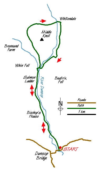
The walk starts in the beautiful village of Dunsop Bridge (Grid ref. SD661501) where car parking is available. Exit the car park (passing the toilet block) and cross over the road to the Telephone Box to discover you are in the centre of The British Isles! The phone box has a unique number to commemorate this feature.
Cross over the road again to pass the petrol station and post office turning right down the lane prior to the bridge. Continue along the lane (heading north) through fields, behind the cottages then over the River Dunsop. On reaching the west bank turn right and follow the road passing Bishops House (grid ref. 655515).
As you go further into the valley you should see lots of bird life. Look out for the Buzzards high above you and Oyster Catchers near the river. You will eventually come to a concrete Salmon Ladder, do not cross over the bridge but continue along the road ignoring the footbridge on your right. The road then climbs to meet a road from coming in from the right. There is a finger post sign indicating local farms.
Leave the road here and take the bridleway that contours across the western flank of Middle Knoll looking down on both Brennand Farms. This bridleway terminates at a gate just before a brook (Grid ref 649547). Go over the stile on the right. The onward path is very wet and at times not visible. It passes a fenced lake on the left and ends with a very short steep descent to the picturesque Whitendale Farm (Grid ref 661550).
Walk straight on, to the right of the accommodation, through the farm gate then turn right at the end of the wall to follow the path on the other side of the river to the Salmon Ladder and back to your start.
Messaging & Social Media
Message Walking Britain and follow the latest news.

Mountain Weather
Stay safe on the mountains with detailed weather forecasts - for iOS devices or for Android devices.