Walk 2576 - printer friendly version
Fernilee Reservoir, Goyt Valley Walk
Author - Mike Bexley
Length - 6.0 miles / 9.8 km
Ascent - 900 feet / 273 metres
Grade - easy
Start - OS grid reference SK013756
Lat 53.277379 + Long -1.9819643
Postcode SK17 6SX (approx. location only)
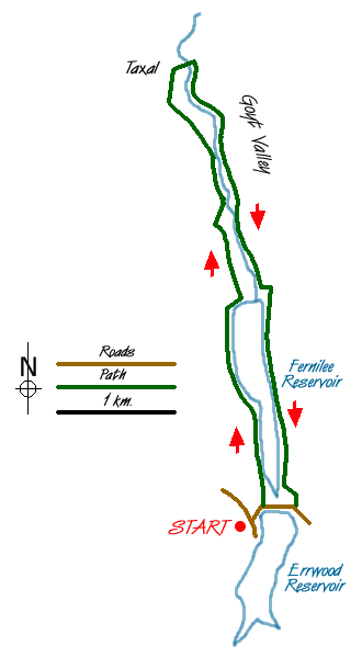
This relaxed short Peak District walk in Derbyshire is beautiful in any season but the woods viewed across the water in spring and autumn, are exceptional. I have also provided two options that reduce the distance. All the paths are well defined making direction finding very easy.
Start from the car park that overlooks Errwood Reservoir (Grid ref SK013756) opposite the Sailing Cub. Walk down the road towards the dam to take the footpath on the left heading north. Just after this footpath gate from the road, take the path ahead that eventually descends to Fernilee Reservoir built in 1938. This old path, part of the vast estate that occupied this area prior to the arrival of the reservoir, threads its way through the trees ending at a narrow lane (Grid ref. 011776). Turn right down the lane to the dam.
This is your first option to cut short your walk by crossing over the dam and turning right to pick up the returning walk.
Do not cross over the dam but turn left along the farm road, then just before the first farm - Knipe Farm (grid ref 011783), descend right down to a small gate in the wall. Then continue left to follow the wall to the back of the house. Descend right down the field to a five bar gate with a fat yellow arrow painted on it. This leads at first to a green lane down to the River Goyt then continues as a footpath alongside the river to a footbridge (Grid ref 011787).
Here is the second option, cross over the bridge, turn right and pick up the returning walk.
Continuing with the full walk, do not cross over the river but follow the path alongside the river then climbing up through the woods to exit onto fields. The clear path crosses the fields to the narrow Whiteleas Road (Grid ref 006795). Turn right along this road through the gate to the church (Grid ref 006798).
At the church wall turn right down the steep lane that passes through the cemetery to a river ford. To save getting your feet wet cross over the bridge on the left then climb up the path ahead to turn right through the gate to the footpath. The footpath follows the river, now on your right, passing the bridge (the second option joins here) to the very large concrete building housing the water treatment plant.
Keep the building on your right to follow the service road that climbs up to a lane, turn right towards the dam (the first option joins here). Then go left on the footpath that used to be the railway (Grid ref 015777). This level path ends near Errwood Dam completed in 1967. Proceed through the small gate on your right following the path that keeps to the foot of the dam then climbs up the steep hill to the gate to the road. Turn right back to your start.
Messaging & Social Media
Message Walking Britain and follow the latest news.

Mountain Weather
Stay safe on the mountains with detailed weather forecasts - for iOS devices or for Android devices.