Walk 2580 - printer friendly version
Golden Cap & Charmouth Walk
Author - Reg Carr
Length - 5.0 miles / 8.1 km
Ascent - 1200 feet / 364 metres
Grade - easy/mod
Start - OS grid reference SY389935
Lat 50.737882 + Long -2.8672242
Postcode DT6 6SD (approx. location only)
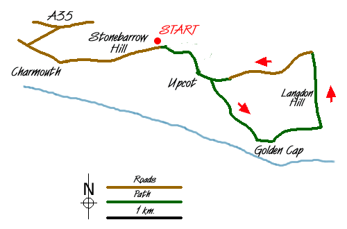
From A35 take slip road into Charmouth and at south end of village look for National Trust sign to Stonebarrow Hill. Go carefully up a very narrow lane until this opens out onto a grassy area on Stonebarrow Hill. This is the car park and provides a convenient start to the walk (Grid ref. SY389935). This is a good area for a picnic and a lazy afternoon on a warm summer's day. This walk is in a quiet part of West Dorset and offers good coastal and country views.
Leave the car park and walk east along the track until you reach a gate (Grid ref. SY396935) and follow the path down the hill. The path becomes a track down to a farm at Upcot (Grid ref. SY396930). After the farm turn right across the field on a path which joins a narrow road (Grid ref. SY399927) and go right on this down to the hamlet of St Gabriel.
This was once a much larger village but much of it fell into the sea because the Blue Lias clays here are very unstable. Go past the cottage and the ruined church on the left and then take the path on the right which goes steeply up the hill to the crest of Golden Cap (Grid ref. SY406922).
Golden Cap is the highest cliff on the south coast of England and is 191m above sea level. There can be brilliant views from the crest but keep well clear of the cliff edge. To the west you see Charmouth and Lyme Regis and to the east Seatown, Bridport and Chesil Beach.
Continue along to the Trig Point and go down the steps and made up path, and across the stile. Continue straight across to the wood (Langdon Hill - Grid ref. SY411923 and not to the right which will take you down into Seatown with a consequent steep climb back up!
Walk through the wood and on to the track at the north end. Go north until it joins a narrow road (Grid ref. SY411933) and turn left on this road. Continue past Norchard Farm to Upcot (Grid ref. SY396930) and then back up the track to the car park on Stonebarrow Hill.
Messaging & Social Media
Message Walking Britain and follow the latest news.

Mountain Weather
Stay safe on the mountains with detailed weather forecasts - for iOS devices or for Android devices.