Walk 3029 - printer friendly version
Derwentwater & Walla Crag Walk
Author - Lou Johnson
Length - 6.5 miles / 10.6 km
Ascent - 1550 feet / 470 metres
Grade - easy/mod
Start - OS grid reference NY265228
Lat 54.595015 + Long -3.1390793
Postcode CA12 5DJ (approx. location only)
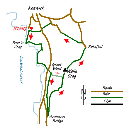
Keswick is a popular town and sees many visitors. It is also well served by public transport so this walk might prove useful to those without their own private transport. This Lake District walk starts from the large car park near the landing stages on Derwentwater (Grid ref. NY265228).
Exit the car park and turn left and walk down to Derwentwater. Keeping the lake on your right continue past the landing stages towards Friar's Crag from where the view south into the 'Jaws of Borrowdale' is first seen. The path continues, sometimes leaving the lake shore where it diverts inland as far as Calfclose Bay where the main Borrowdale road is met (Grid ref. NY 270213). Cross over this road taking extreme care into Great Wood towards the car park.
Reaching the car park turn right and walk to the southern pedestrian exit. This path leads towards a bridge over Car Gill (Grid ref. NY 271210). Go over the bridge and continue straight ahead. This path gradually climbs below the crags of Brown Knotts to reach Ashness Bridge, which is often the subject of picture postcards. Having enjoyed the view retrace your steps a short way as far as the wall and take the right hand path.
This path leads uphill with a couple of short sections where you might need hands. The view improves as you get higher with an excellent panorama south, which on a clear day, will include Scafell Pike (England' highest mountain). Eventually the grade eases and ahead you will see the top of Walla Crag, which is located on the other side of the stone wall.
After enjoying the view continue along the path for a short way before crossing the wall into open country once more. The onward route continues north with the wall to your left on a broad easy to follow path. Ahead the views are towards Blencathra. The path descends quite steeply at times to reach a lane at Rakefoot (Grid ref. NY 283221). Go down the lane for a short way keeping a careful watch for a half hidden path on your left (Grid ref. NY 282222) which should be followed down to the bridge over the beck and downhill towards Keswick.
The path continues with the beck to your right through a wood to reach a road (Grid ref. NY 275226). Follow this road for about 500 metres and locate the signed footpath on your left (grid ref. NY 272229). Take this and continue through Castlehead Wood, gaining some height, before reaching the main road. Turn left for a short way. On the opposite side of the road there is signed path. Take this into Cookshot Wood. Just after entering this wood turn right and follow the path to car park where the walk started.
Note - You can omit the section to Ashness Bridge by taking the signed path on the north bank of Car Gill (Grid ref. NY 271210). This path is steep and is stepped for most of the way and leads you almost directly to the top of Walla Crag.
Messaging & Social Media
Message Walking Britain and follow the latest news.

Mountain Weather
Stay safe on the mountains with detailed weather forecasts - for iOS devices or for Android devices.