Walk 3062 - printer friendly version
Pen yr Ole Wen Walk
Author - Lou Johnson
Length - 5.0 miles / 8.1 km
Ascent - 2600 feet / 788 metres
Grade - moderate
Start - OS grid reference SH649603
Lat 53.122704 + Long -4.0203408
Postcode LL57 3LZ (approx. location only)
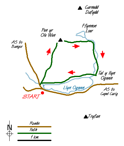
An ascent of Pen yr Ole Wen is a short but relatively demanding Snowdonia (Eryri) walk that offers fine views of the Glyders, Carneddau and sections of the Snowdon massif. It starts from Ogwen Cottage (Grid ref. SH649603) where there are refreshments and toilets. Parking is limited but alternatives can be found close by.
From Ogwen Cottage walk north along the A5 towards Bangor crossing the outflow from Llyn Ogwen. Cross the road and locate the stile just across the bridge where a National Trust sign has a useful diagram showing the first section of the route up Pen yr Ole Wen, which could be missed quite easily. Having located the rocky "gully" scramble upwards to join a well maintained path that climbs quickly towards the summit.
The flagged path disappears about one third of the way to the summit. From this point onwards the path is rougher and there are sections where a number of alternatives make navigation slightly tricky. However continue upwards across sections of scree and along paths with some short scrambles for variety to turn a large crag on its right hand flank. Once this has been passed the worst of the ascent is over and the path becomes less steep.
The views throughout the ascent are superb especially across to Ogwen Valley to the Glyders but also down Nant Francon towards Bangor and Anglesey. Reaching the domed summit area of Pen yr Ole Wen it is better to ignore paths going half left, instead continuing on a wider path that follows the edge of drop down into Nant Francon on your left. Note that because of the domed nature of Pen yr Ole Wen's summit that the best views are away from the true highest point, which is marked by a small cairn.
Having reached the summit you do however get better views along the main Carneddau ridge to Carnedd Dafydd and Carnedd Llewelyn. From the summit head just south of east to pick up a clear path that descends along a crag with steep drops to Ffynnon Loer below. The route is clearly defined for the most part. Nearing the level of the lake there is one section where you need to negotiate a rocky gully, which is not easy to avoid.
Reaching the outflow stream from Ffynnon Loer (Grid ref. SH 664 620) turn right and follow the stream downhill to Tal y llyn Ogwen Farm. Just before reaching the farm turn right at a yellow waymark to take the path that follows the north shore of Llyn Ogwen. At times this path is not easy to follow but it is better to keep away from the boggy areas nearer the lake maintaining height and following the electricity supply for the farm. As you near the end of the lake the path has a couple of short sections of scrambling before you reach the A5 where you turn left back to the start pleased that you ticked off Pen yr Ole Wen from your list.
Messaging & Social Media
Message Walking Britain and follow the latest news.

Mountain Weather
Stay safe on the mountains with detailed weather forecasts - for iOS devices or for Android devices.