Walk 3064 - printer friendly version
Hailes, Beckbury & Sudeley from Winchcombe Walk
Author - Lou Johnson
Length - 10.0 miles / 16.3 km
Ascent - 1125 feet / 341 metres
Grade - moderate
Start - OS grid reference SP023284
Lat 51.954085 + Long -1.9679409
Postcode GL54 5PZ (approx. location only)
The Cotswolds are often seen by outside observers as being a microcosm of the English landscape. This walk, although lengthy, is never strenuous and provides the walker with a wide range of views of this green and pleasant landscape interspersed with points of interest including an abbey, a castle, a rather nice rural church together with a pleasant market town with an eclectic mix of attractive buildings.
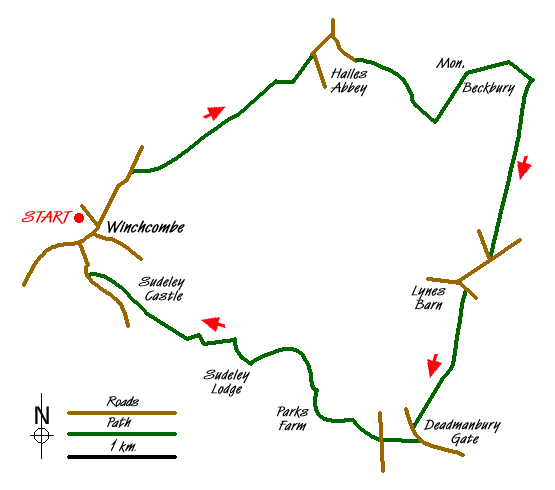
The start is the town of Winchcombe. There is a long stay car park signed from the main roads into the town (Grid ref. SP024283). From here locate the road to Broadway (B4632) and walk north. After about 500 metres and shortly after crossing the River Isbourne turn right at a Cotswold Way fingerpost down Puck Pit Lane. As one might expect, the Cotswold Way is effectively way-marked crossing a number of fields and pastures to reach Salter's Lane (Grid ref. SP 0452980). Continue down this lane towards Hailes turning right at the first road junction (Grid ref. SP 047301). After a short way take the signed footpath on your left down a drive. This leads to a path across a field with the ruins of Hailes Abbey on your right.
This path joins a road. Opposite is the small parish church, which I found more interesting than the Abbey ruins although this may be due to my personal tastes and interests. After exploring the points of ecclesiastical interest head east up the road passing Hailes Fruit Farm on your right. The road becomes a track and continues to climb steadily offering wider views across the countryside.
Just after passing the end of Hailes Wood (Grid ref. SP 059 293) turn left onto the Cotswold Way. The path climbs across fields to reach Beckbury Camp ( an iron age fort?) which has recently undergone some restoration work. The strategic value of this fort is obvious as the views are tremendous especially north towards Stanway and Stanton.
Stay on the Cotswold Way turning right at a small coppice before reaching a track - Campden Lane (Grid ref. SP 069 298). Turn right and follow the high ground to reach a road junction (Grid ref. SP 065 280). Ignore the lanes going left and right, continuing straight ahead to a further junction (Grid ref. SP 061 278) where you turn left. Continue down the lane as far as Lynes barn where you turn right on a bridleway, which is a continuation of Campden Lane used before.
Reaching a road at Deadmanbury Gate, turn left. After 200 metres turn right down a bridleway. Cross over the Salt Way (Grid ref. SP 054 262) and continue down a farm access road. The view opens out once more with Winchcombe soon coming into view. Pass Park's Farm and imposing Sudeley Lodge.
Approximately 300 metres past the latter turn left onto a footpath. This descends a field. Turn right and then left along the next field's boundary to reach a path junction (Grid ref. SP 034 272) where you go half right (north-west) to cross the parkland in front of Sudeley Castle. Follow the castle's main drive towards the road and walk past cottages to reach the High Street where there is a wide range of establishments offering refreshments. All that remains is to walk the short distance back to the car park.
Messaging & Social Media
Message Walking Britain and follow the latest news.

Mountain Weather
Stay safe on the mountains with detailed weather forecasts - for iOS devices or for Android devices.