Walk 3098 - printer friendly version
Tring & Wendover Woods Walk
Author - Barry Mackie
Length - 7.5 miles / 12.2 km
Ascent - 910 feet / 276 metres
Grade - easy/mod
Start - OS grid reference SP924110
Lat 51.790035 + Long -0.66172518
Postcode HP23 6AS (approx. location only)
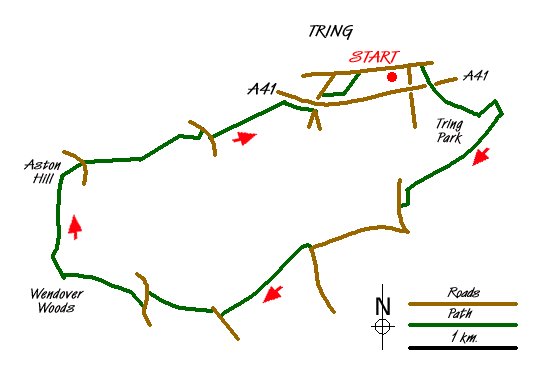
This circular walk starts and finishes at the Hertfordshire town of Tring, which is close to the A41 trunk road. During the walk you'll cross beautiful parkland, see an impressive obelisk and cross some of the wonderful Chiltern Hills on two tracks that are both claimed to be Britain's oldest road. The county tops of Hertfordshire and Buckinghamshire are visited, and on the way back, there are some great views over the vale of Aylesbury.
Roadside parking is available in the vicinity of Hastoe Lane, near the Zoological Museum (grid ref SP 924110). Head east along the road by the southern side of the museum for a short distance and reach the footpath signposted to Tring Park. Follow this path to reach and cross the footbridge over the A41 to enter the park. Here the preferred path is not initially apparent, so head in a south easterly direction across the open parkland and soon pick up the waymarkers directing you up the slope to the treeline. Entering the woods, turn left to reach the imposing 200 year old, 50ft high obelisk, (Grid ref. SP932106). With no inscription or plaque, its purpose remains a mystery. Whilst there is much conjecture, locally it is known as "Nell Gwynn's Statue".
Leave the obelisk taking the southeast path to reach the Icknield Way; one of two tracks on this walk that may be the oldest known road in Britain. Follow the Way, predominantly through light woodland, in a south westerly direction until reaching Bishop's Wood, where it veers south to reach the road (Marlin Hill). Walk down the road and turn right into Church Lane, which is also signposted as the Ridgeway. This is the second track that may just be Britain's oldest road. Stay on this road until at a bend to the left; you turn right into Pavis Wood. Difficult to spot, no cairn or trig point to see, but this is the highest point in Hertfordshire (802ft/244m, grid ref. SP914092).
Stay on the Ridgeway, here quite muddy after recent rainfall, but easily passable, and continue through the woods in a south westerly direction. At the minor road leave the Ridgeway and again take the Icknield Way heading in a north-west and then westerly direction to reach the road. Turn left here for a short distance, and take the first signposted footpath across the field to your right. At the edge of the field, walk through the woods to reach the Visitors Centre at Wendover Woods. Facilities here include toilets, car parking, picnic areas and an excellent café.
Also close by is a large direction post indicating where the highest point of the Chiltern Hills (and also the county of Buckinghamshire) is. With this additional information, an OS map and a compass, the summit should be easy to find, but it isn't! After spending some time searching through the undergrowth, we found a superb cairn, some 4ft high with a detailed inscription plate attached. (876ft/267m, grid ref SP890089). It seems almost churlish to say this, but even to the naked eye, this surely isn't the highest point! That said, Wendover Woods and its summit celebration really are worthy of a visit.
Leave the summit point and head north on the road until you reach the path (Grid ref. SP889098) that takes you northwest across to the summit and trig point of Aston Hill (854ft/260m). Continue over the hill to the road and walk down a short distance to the path just before you reach the mountain bike area. Follow this path with its gradual descent and pause for some fine views across the vale of Aylesbury. At the road, turn right, then left to follow the path across open fields heading northwest. Soon you are close to the A41 road and the path runs parallel to it until you reach a bridge. Turn left under the bridge then right to take the footpath over the field. The path then turns northeast and through the coppice of Woodland Close Wood to Park Road. Turn right here and, if you avoid the temptation of the Public House, it won't take too long to get back to your starting point.
Messaging & Social Media
Message Walking Britain and follow the latest news.

Mountain Weather
Stay safe on the mountains with detailed weather forecasts - for iOS devices or for Android devices.