Walk 3105 - printer friendly version
Preston Bagot from Henley-in-Arden Walk
Author - Lou Johnson
Length - 4.7 miles / 7.6 km
Ascent - 450 feet / 136 metres
Grade - easy
Start - OS grid reference SP151660
Lat 52.291928 + Long -1.7800302
Postcode B95 5SS (approx. location only)
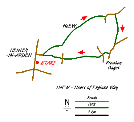
This half day walk explores the Warwickshire countryside lying to the east of Henley-in-Arden. Generally the paths are well signed and maintained. The outward route follows the Heart of England Way for just two miles before continuing across country using Preston Field Lane to Preston Bagot with its picturesque church. The remainder of the route follows field paths back to Henley-in-Arden.
The start is the High Street in Henley-in-Arden by the church (grid ref. SP151660). On Sundays on-street parking is plentiful although during the week you will need to park at one of the free long stay car parks as there is a 2 hour limit on on-street parking. After parking, walk down Beaudesert Lane on the south side of the church. Follow this lane past a further church and locate a cast iron gate nest to a footpath sign on your left. Ignore the signed footpath, instead go through the gate and climb the steep path onto the earthworks that were once part of the Motte and Bailey Beaudesert Castle. Continue across the crest of the earthworks appreciating the excellent view it provided of any impending attack.
Continue on the clear path as it drops down to cross one of the old defensive ditches before climbing again up to a bench. Pass the bench and following the Heart of England Way continue to a rather overgrown Edge Lane (grid ref. SP163667). Following the waymarks, cross Edge Lane and continue on the clear paths to pass Holly Bank farm and reach a lane (SP173672). Turn left along the lane (Henley Road) for about 400 metres to reach the northern end of Preston Field Lane (grid ref. SP177673). Turn right down the lane and follow it as it undulates through pleasant countryside.
Reaching a lane (grid ref. SP176663) turn right and continue along the lane until you reach Preston Bagot church on your right. Follow the signed footpath across its south side (with the church on your right) and follow the footpath which soon becomes enclosed by hedges down to a lane (grid ref. SP173660). Go straight cross and join the footpath opposite. This continues across fields to reach a junction of paths (grid ref. SP167659). Go straight on here and follow the way marked path across more fields to reach an overgrown lane (grid ref. SP163658). Follow the clear path as it dog-legs through the undergrowth to emerge into a field. The path then leads past some stables on your right to a lane (grid ref. SP160658). Turn right for a few yards and take the signed footpath on your left. This crosses field, descends through some bushes to reach a small park. Go through the gat on your right and walk between bungalows to reach a cul-de-sac road. Cross the road and follow the enclosed path between bungalows. At the junction by the school playing field, turn left and follow this path alongside the earthworks of Beaudesert castle back to Beaudesert Lane and Henley-in-Arden High Street.
Messaging & Social Media
Message Walking Britain and follow the latest news.

Mountain Weather
Stay safe on the mountains with detailed weather forecasts - for iOS devices or for Android devices.