Walk 3111 - printer friendly version
Barley Circular Walk
Author - Allan Friswell
Length - 7.5 miles / 12.2 km
Ascent - 1100 feet / 333 metres
Grade - easy/mod
Start - OS grid reference SD862397
Lat 53.853345 + Long -2.2112685
Postcode BB9 6JQ (approx. location only)
An easy going walk except for the final climb from Old Hall Farm to the ridge over Barrowford which is very steep. A fine mixture of deciduous and coniferous woodland, open grass meadows, with the very pretty village of Barley as a bonus.
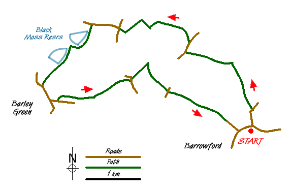
From the car park in Barrowford Heritage Centre (grid ref. SD862397) go through a gate and walk to the A682 with Pendle Water on your left. Turn left across the bridge, cross the road with great care and then head right into Foreside which soon becomes Barleydale Road. At Water Meetings, where Blacko Water merges with Pendle Water cross the bridge and turn left. Follow the stream to a footbridge after which you climb to a wooden gate on the skyline. (Aim 100 yards to the right of the metal gate.)
Keep ahead. After the next stile continue with the wall on your right to reach Blacko Bar Road. Leaving the Pendle Way go straight ahead on a farm track to Bank End. Follow the path as it skirts to the right of the drive. Cross the stile and immediately turn right and begin a descent that brings you quickly to another (extremely awkward) stile and then, beyond a gate, to a broad footbridge over a brook. Follow the track upwards which is joined by a hedge on the right. Cross a wooden stile at grid ref. SD846417. At the top of the slope take the left-hand gate which leads up to Lower Briercliffe Farm's drive, and turn left into the farm by the right-hand gate.
At the far end of the yard turn right through a gate and then turn sharp left to reach a very narrow stile. Cross the stile and keep ahead and slightly left, aiming for the building of Higher Briercliffe. Cross another difficult stile and then, at the building, (and avoiding the temptation to follow the proper right of way through the immaculate garden!) go around the garden perimeter to arrive at a stile, after which turn right and make for the cattle grid and track. Turn right, then almost immediately left towards Barley, misleadingly signed as 3 miles away. Just beyond Black Moss Farm turn left through a metal kissing gate and drop towards Upper Black Moss Reservoir.
Pass through a gap in the wall next to a redundant ladder stile, and cross a footbridge to turn left onto a substantial track. Pass Upper and Lower reservoirs on your right to reach Barley close by the Methodist Chapel. Turn left into the village. Follow the path alongside the playground which will lead you to the information centre car park. Walk to its far end on the right to take the track to reach White Hough Farm after 15 minutes. Here turn sharp left through cottages and follow a tarmac drive up the hill. Soon, at a small brick building on the right, you branch off and pass below the outdoor education centre.
The path leads through woodland. Ignore the stile when you reach it, but turn left along the wood's edge, following the diverted path. At the two footbridges, bear left up steps to a stile, follow the wood's edge, and after a kissing gate, go downhill to the farm track. Take this track to reach a lane where you turn left uphill and then, after 50m turn right along another track. At 200m the Pendle Way turns sharply right (grid ref. SD840408) and descends steeply towards Roughlee. It passes on the left of Croft House.
Keep ahead to cross a footbridge, then ahead to a squeeze stile, and ahead again via two metal gates to Blacko Lane. Continue along the lane, and over a metal stile to drop down to Pendle Water which you cross by a number of concrete stepping stones. Follow the path up the very steep slope keeping to the left of a prominent tree on the skyline. Once your pulse rate has dropped to the low hundreds cross the stile in the wall at the top of the hill at grid ref. SD848403 and commence dropping into Barrowford. Keep the hedge on your right, but after passing on the left of a barn and negotiating a very tight stile, you descend with it on your left.
Two fields beyond the barn you arrive at a T junction of paths as indicated by waymark signs on a footbridge. Here turn left and after crossing a stile turn right onto a farm track. This soon brings you to Pasture Lane which you descend to reach the A682, crossing it with care to a footbridge over Pendle Water. Turn left and walk through the park to reach Pendle Heritage Centre.
Messaging & Social Media
Message Walking Britain and follow the latest news.

Mountain Weather
Stay safe on the mountains with detailed weather forecasts - for iOS devices or for Android devices.