Walk 3199 - printer friendly version
Whitbarrow Fell from Mill Side Walk
Author - Andy Smith
Length - 7.0 miles / 11.4 km
Ascent - 1200 feet / 364 metres
Grade - moderate
Start - OS grid reference SD452840
Lat 54.248735 + Long -2.8425154
Postcode LA11 6SQ (approx. location only)
Whitbarrow is a modest summit rising to 220m but it dominates the skyline when the Lake District National Park is entered from the southernmost point. It is a classic result of ice age activity and an area of special geological interest to this day. As this is an outlying fell it can be fairly quiet on weekdays and during off-season but do not expect to be alone at weekends.
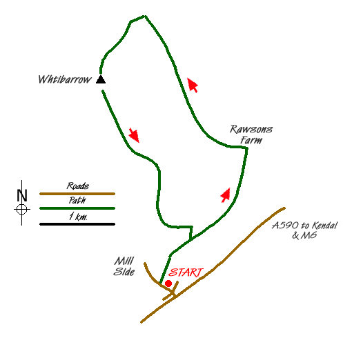
This Lake District walk starts from the small hamlet of Mill Side just off the busy A590. Leave the M6 at junction 36 heading westbound into the Lake District on the A590 signed Barrow-in-Furness. Drop down to the roundabout at the first major junction from the M6 and continue towards Barrow. After approximately 2 miles and after passing the car garage to your right, take the tiny road signed Mill Side/Beck Head on your right. Just after crossing the cattle grid, parking can be found in a small layby or along side the quiet road (grid ref. SD452840).
After parking walk into the hamlet and take the farm track (grid ref. SD449840) heading north, which is has a public footpath sign. Walk through the farm and into the woods via a stile. Very shortly the path meets another track (grid ref. SD451844). Turn right here even though you might be tempted to go straight on. The track continues passing a private house on your right. The onward route passes below White Scar, which now starts to tower above you on your left. Reaching Rawsons Farm (grid ref. SD463860), turn left past the house. The path starts to climb steeply into the woods on the zigzag path.
Once the woods have been cleared the views behind are very impressive looking back over the Lyth Valley. The village of Levens rises sharply out the flat ground. Continue uphill onto the clearing where a crossroads is reached. Turn right here following the footpath markers and continue to Barney Crags. The geology in the area is very interesting with huge ridges cutting across the landscape as far as the eye can see. After 200m turn left at grid ref. SD448880 and stay on the path. You are now heading directly for the summit of Whitbarrow, which can just be made out in the distance with its huge oversized summit cairn.
After a while the summit is reached where you take in stunning views of Morecambe Bay to the south with views of north Wales on a very fine day. To the west the Isle of Man can just about be seen whilst views across into Yorkshire are taken in to the east.
Leave the summit to the south on the very large track heading gently downhill. This follows a huge stone ridge and meets up with a stile at grid ref. SD447861, which is marked with a National Trust sign. Stay on this track as it leads you down into the woods. It is well worth noting that this track is not well defined on OS maps and appears to end at grid ref. SD450850. However by following a south-easterly bearing, keeping the Kent estuary in view, the descent should present no problems as the path is very clear.
The track soon drops out the woods and starts to follow round the base near to where you went up. After a short while a small but clear path meets you to your right at grid ref. SD457849. Take this as it leads you down onto your original path just 25m away. Turn right and head back the way you came through the farm and back to your car.
Messaging & Social Media
Message Walking Britain and follow the latest news.

Mountain Weather
Stay safe on the mountains with detailed weather forecasts - for iOS devices or for Android devices.