Walk 3220 - printer friendly version
Wetherlam via Red Dell Walk
Author - Lou Johnson
Length - 7.0 miles / 11.4 km
Ascent - 2500 feet / 758 metres
Grade - moderate
Start - OS grid reference SD303975
Lat 54.368225 + Long -3.0743014
Postcode LA21 8EL (approx. location only)
This approach to Wetherlam is little used and offers a quiet ascent from an interesting valley. In the upper sections the lack of clear paths means you need some navigational skills and in addition the climb is quite steep for some 800 feet. Once on the summit the views are good and the descent route past Levers Water and through the Coppermines Valley is interesting.
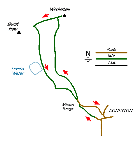
This Lake District walk starts from the main pay and display car park (Grid ref SD303975) in Coniston adjacent to the Tourist Information office. There are other places in the village where you can park for free but these are in short supply certainly in season. Exit the car park and turn left and walk to the main road. Turn left along the main road. Cross the river and then turn right on the Walna Scar Road towards the Sun Hotel. Turn right immediately after the hotel and join the main footpath that leads to the Old Man of Coniston. The right of way leads to the Miners Bridge (grid ref. SD293981). Here you leave the path to the Old Man and cross the bridge. Turn left up the road and just after the waterfalls on your left bear right at the junction of roads tracks. This leads you towards a row of cottages. Before reaching these bear right on a track and continue climbing, keeping right at the first junction. Then follow the track that runs above the cottages and roughly parallel to them.
This track leads easily past a tower on your left. Also on your left is the impressive Kennel Crag. You can also see evidence of past mining activity in the area. The track leads into Red Dell, a wide valley, which offers the key to this ascent of Wetherlam. The path continues into the valley without any problems apart from occasional wet areas. The ascent at this stage is gentle and leads to a sheepfold. As the valley narrows the path climbs more steeply with some small waterfalls adjacent to the path. At this stage you should look for a suitable place to cross Red Dell Beck.
Once across you should locate evidence of previous walkers and this does develop into a feint path. However it can easily be lost. At grid ref. SD285003 (approx) turn north east away from the main valley and start to climb the steep slope. There is intermittent evidence of a rudimentary path. Continue climbing, continually making sure you know where you are in relation to Wetherlam's summit. As the gradient eases bear slightly left and follow a more northerly direction through a hollow aiming to walk just to the west of the summit. By doing this you should intersect the main path from Swirl Hause. Turn right and it is an easy climb to the summit.
All the hard work (both navigational and physical) is now over. Go west on the main path and descend across the northern flank of Black Sails to Swirl Hause (grid ref. SD278007). On the other side of this col is Prison Band which leads to the summit of Swirl How. At the col, turn left and start the descent to Levers Water. In general the path is good but as you approach Levers Water the path is often very wet and diversionary tactics are necessary. Assuming you have avoided the worst, continue along the shore of the reservoir to reach the dam (grid ref. SD281992).
The path becomes a wider track and this is followed downhill. There are a number of options with some short cuts. Careful map reading will avoid heading back over to Red Dell and instead you should continues down to the floor of Coppermines Valley. Reaching the main track, walk back towards Coniston. At Miners Bridge you can either retrace your original route past the Sun Hotel or continue straight down the road into Coniston.

Mountain Weather
Stay safe on the mountains with detailed weather forecasts - for iOS devices or for Android devices.

