Walk 3328 - printer friendly version
Eagle Crag & Seargeant's Crag from Stonethwaite Walk
Author - Lou Johnson
Length - 7.0 miles / 11.4 km
Ascent - 2100 feet / 636 metres
Grade - moderate
Start - OS grid reference NY262137
Lat 54.513207 + Long -3.1414353
Postcode CA12 5XG (approx. location only)
This entertaining Lake District walk takes in two Wainwrights in an area that sees few walkers despite its proximity to Borrowdale. The village of Stonethwaite remains relatively unspoiled. Stonethwaite Beck which runs through the village is fed by Greenup Gill and Langstrath Beck and during the course of this walk you will get to see something of these two rivers and the valleys that contain them.
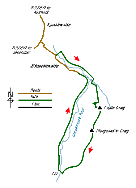
There is limited parking in Stonethwaite and when this walk was researched I found a space by the post-box and telephone box (Grid ref. NY262137) where I was able to park without obstructing normal village life. After parking cross Stonethwaite Beck and turn right upstream through pastures with a view ahead to Eagle Crag which forms the first objective of the day. After just under a mile you reach a footbridge (Grid ref. NY274129) near Smithymire Island. Cross this and turn left to walk upstream alongside Greenup Gill. Go through two walls and immediately after the second turn right and, with the wall on your right, follow the small path uphill.
Passing large boulders on your right the path goes through the wall on your right and continues climbing with crags on your immediate left to reach a gully. Turn left into this gully and after a short scramble you emerge onto a terrace where you turn right. Continue along this level section and bearing left carefully follow the feint path as it zigzags up through rocks to lead you without further problems to the summit cairn on Eagle Crag (Grid ref. NY275120). The view west and north is good and you can rest awhile trying to name the summits. To continue take the path heading south across roughish ground to the next objective namely Sergeant's Crag (grid ref. NY274113). This is clearly in view in normal visibility and the path easy to follow.
Having reached this second vantage point it is important to look at the terrain ahead. There are intermittent paths across the next section of route although you can easily get fooled by sheep trods. Ideally you need to cross the wall just south of Sergeant's Crag and follow a developing path that twists and turns to pass above Bull Crag (Grid ref. NY271108). Losing some height, but not too much, keep walking south towards Brown Crag (Grid ref. NY271102). Having reached this point, turn downhill following one of the small becks tumbling down the fellside. The going is quite steep but soon after starting the descent you will be able to see the footbridge across Langstrath Beck (Grid ref. NY264100). This bridge is the next objective and by making a beeline for the bridge some of the steepness of the descent is removed.
Cross the bridge over Langstrath Beck to gain its western bank. Turn north (right) and follow the clear path through the delightfully peaceful valley of Langstrath for about 2 miles. At a junction of tracks (Grid ref. NY272128) near Smithymire Island, bear left and follow this track back to Stonethwaite. Alternatively you can proceed further to the junction of Langstrath Beck and Greenup Gill and then turn left to follow Stonethwaite Beck for part of the way back to Stonethwaite, rejoining the previously mentioned track nearer the village.
Messaging & Social Media
Message Walking Britain and follow the latest news.

Mountain Weather
Stay safe on the mountains with detailed weather forecasts - for iOS devices or for Android devices.