Walk 3352 - printer friendly version
The Greenwich Meridian, near Ware Walk
Author - Barry Mackie
Length - 3.3 miles / 5.3 km
Ascent - 150 feet / 45 metres
Grade - easy
Start - OS grid reference TL371140
Lat 51.807834 + Long -0.012801114
Postcode SG12 7QE (approx. location only)
The Greenwich Meridian (0 degrees 0 minutes longitude) is probably the most important navigational line of them all. This is where the east meets west and from where all time is measured from. Passing through Greenwich, the meridian travels many thousands of miles between the North and South Poles. This walk crosses this important 'line' in rural Hertfordshire.
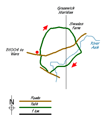
Leave the town of Ware on the B1004, As you reach the edge of the town where the speed limits change, park on the grass verge on the right hand side of the road.(grid ref TL371140). From here walk a short distance up the road and turn left onto the signposted bridle path heading north, just past the Widbury House Nursery.
Follow the clearly defined track, initially with a fenced orchard to your left and arable farmland to your right. Soon passing the orchard, the path heads into open ground and in the distance the outskirts of Ware are seen. Ignore the obvious paths that lead towards Ware, and continue on the bridle way which is gradually easing to the right along to the area known as Wood Lane. Passing the woods on your left, and now heading in an easterly direction, pause at grid ref TL378149. No easy fixes here, we didn't see a stone, a marker or anything to commemorate the meridian passing through here. You just have to locate on your map and then you can "straddle the east and west".
Cross the meridian and continue in a general easterly direction as the track takes you past Swades Farm and then Newhole Farm. Follow the track now veering in a south easterly direction along the Harcamlow Way until you reach the road (B1004).
Cross the road and pick up the bridle path opposite that takes you down through Watersplace Farm and onto Hall Ford at the bottom of the valley. Here the River Ash flows across the concrete track. Take the footbridge to the right of the ford, cross the river and head up the slope towards the woods. Just short of the edge of the woods, there is a well defined path to your right, heading in a south easterly direction. Take this path which will lead you back across open grazing land to a weir on the river in a wooded area.
The path now heads west and as it just starts to veer to the right, stop at grid ref TL379137 as you cross the Meridian again. Searching for clues, right on our line there is an overhead electricity supply pole. Some eight feet up, there is a plastic card with two arrows stencilled onto it, pointing east and west. Could this be the defining marker for the Meridian? Not sure though as it's also showing the line of the power lines!
Continue on the path with the wooded area to your right heading in a general south westerly direction, ignoring the route heading north. Cross the wooden footbridge over the River Ash and travel south easterly using the upper of two parallel paths until you reach the bridge under the road with gates marked as Lee Valley Park. Walk up the steps to your right and onto the concrete drive to reach Hollycross Road.
Cross the road and walk up the side of the field, behind the hedge, to pick up the path at the end of the field. This leads to the right for a few yards, then to a gap where you turn north west and head up the slope to the summit of Widbury Hill. From here there are extensive views of Hertfordshire and The Lea Valley. Continue over the slope to the farm below and then onto the B1004. Turn left and walk back down the road to your start point.
Messaging & Social Media
Message Walking Britain and follow the latest news.

Mountain Weather
Stay safe on the mountains with detailed weather forecasts - for iOS devices or for Android devices.