Walk 3578 - printer friendly version
Hertford and Ware Circular Walk
Author - Barry Mackie
Length - 5.5 miles / 8.9 km
Ascent - 100 feet / 30 metres
Grade - easy
Start - OS grid reference TL327130
Lat 51.799908 + Long -0.076965074
Postcode SG14 1QR (approx. location only)
With Hertfordshire being completely land locked, to enjoy a walk by the water's edge, might mean a two hour drive to the coast, or if you wish to stay local, then alongside a lake or a river. If it's a riverside walk you fancy, then try this one. At Hertford, the county town, the rivers Beane, Lea, Mimram and Rib combine, and then flow on as the Lee Navigation to join the River Thames at Limehouse in East London. There is much to see during this walk, not least a fifth "New River", which despite its name, is neither new, nor a river.
The walk starts at Hartham Leisure Centre on Hartham Common (Grid ref. TL326130). Close by are 3 car parks and Hertford East rail station is only a short distance away.
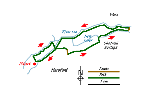
From the front of the Leisure Centre take the footpath heading southwest to the tennis courts to reach the banks of the River Beane and two footbridges. Don't cross the river, but instead turn right and walk alongside its bank to reach another footbridge at Hartham Weir. Cross here to enter Lea Island, keep left and stay alongside with the bank of the meandering Beane until you reach yet another footbridge across the river.
Turn southwest away from this bridge and cross Lea Island to reach Hertford Lock and get your first sight of the Lee Navigation (upstream called The River Lea). This unusual name change for the river was as a result of the alterations made over the centuries to its line, width and depth to allow river traffic to ply between Hertford and London. The lock is operational and if you wait a while you will see one of the many local riverboats go through.
You now enter King's Mead Nature Reserve, a haven for wildlife. Being a natural flood plain, it has never been built on or cultivated. Today only a herd of cattle grazing and a series of irrigation ditches catch the eye, but for those of you who wish to delve deeper, this reserve has much to offer.
Follow the path in an easterly direction, alongside the fence at the edge of the Reserve, to leave at the first kissing gate. (Grid ref. TL338134). Walk south along the rough track for a few yards to arrive at a road (Mead Lane) and the railway line with its pedestrian crossing (Grid ref. TL338132). Take good notice of the clear instructions and lights to cross the line and turn left into the end of Rowley Road. A few yards further take the path on your left back into the Nature Reserve, and continue easterly alongside the edge of the verge towards the flyover (A10) clearly seen in the distance.
Go under the flyover and here there is a choice for the next section. Keep going straight ahead is ok, but the route up the slope then straight on is better, and will offer more impressive views of Chadwell Springs, a source of the New River, soon to come in sight.
Some 50yds before the Springs, to your left, is a causeway across the flood plains (Grid ref. TL349136). Take this route to arrive at the New River and the small but prominent building called White House Sluice (Grid ref. TL348138). Despite the name, it's not a new river, but a 400 year old aqueduct built to provide drinking water to London, a duty it still does. Following the 100ft contour line along the Lea Valley, nothing stood in its way, and even today, it reaches to Stoke Newington, some 24 miles away.
Cross New River and follow its grassy left bank to the town of Ware, passing the Marble Gauge and the grade 2 listed Broadmead Pumping Station as you go. At Ware, go left up the road to the bridge over the Lee Navigation (Grid ref TL359141). Now turn west onto the towpath, and with the river on your right and head back towards Hertford.
Soon you get to see the 19th Century Gazebos on the other bank and then a short distance later, cross the footbridge to visit Ware Lock. Come back over the river and continue to follow the towpath back under the flyover to reach the point were the Beane joins the Lee Navigation (Grid ref TL336138). It is worth pausing here because to the left, just behind the two rivers, is Jacob's Island. Here otters were reintroduced into the wild some 15 years ago in a habitat that perfectly suits their requirements. If you're lucky, you may just spot one.
Continue alongside the riverbank to reach Hertford Lock again. Don't take your earlier route back over Lea Island, but instead stay on the towpath alongside the river until you reach the road bridge at Hertford Basin, a large mooring and turning area for the riverboats (Grid ref. TL329130). Cross the road bridge and then immediately cross the two short footbridges to reach the footpath on the far bank. Turn left on this path alongside the River Lea and soon you will be back at the Leisure Centre and your start point.

Mountain Weather
Stay safe on the mountains with detailed weather forecasts - for iOS devices or for Android devices.

