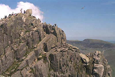
Tryfan & the Eastern Tops from Ogwen Valley
Snowdonia/Eryri Walk
Nat Park - Snowdonia - Glyders Tryfan
County/Area - Conwy
Author - Lou Johnson
Length - 5.8 miles / 9.3 km Ascent - 2640 feet / 800 metres
Time - 5 hours 30 minutes Grade - hard
Maps 

| Ordnance Survey Explorer OL17 | Sheet Map | 1:25k | BUY |
| Anquet OS Explorer OL17 | Digital Map | 1:25k | BUY |
| Ordnance Survey Landranger 115 | Sheet Map | 1:50k | BUY |
| Anquet OS Landranger 115 | Digital Map | 1:50k | BUY |
Walk Route Description
Click image to visit gallery of 4 images.
Tryfan is one of the most recognisable summits in Snowdonia (Eryri). At first sight it is an intimidating mountain having the classic pointed shape, rugged crags and a perfect position. Although a comparatively short walk of around 6 miles, around 2500 feet of ascent are undertaken, much of it over strenuous territory. However, it is a walk most able bodied people can undertake although it must be stressed that Tryfan is not a mountain to be treated lightly. In bad weather - snow and ice or high winds - it can be a dangerous place to be. This walk shares the first section of route with Walk 1215.
To start this Snowdonia (Eryri) walk, you can park your car at the farm for a small charge or alongside the A5. The objective is obvious and it is an easy walk up to the right of Tryfan Bach to reach the start of the steep crags that form Tryfan. I chose the "Heather Terrace" path, which is marked on the OS 1:25000 map. The path can be clearly seen on the approach and its position should be noted. This route provides a moderate way to the summit. Picking up its start is difficult but once on it the way ahead is obvious. Quite quickly you reach the col between the Main and South peaks of Tryfan and from here it is a scramble over large rocks to the summit. Apart from one awkward section it is a straight forward scramble. The summit is a wonderful viewpoint and far below you can see the A5 threading its way alongside Llyn Ogwen. To continue return to the col. Instead of dropping down to the "Heather Terrace" clamber up and over the South Peak to Bwlch Tryfan.
From here take the "Miners Path" - this heads south and descends slightly before climbing steadily onto the ridge between Glyder Fach and Y Foel Goch, which is our next objective. Some of the best views of Tryfan are to be had on this section especially near the small tarn "Llyn Caseg-fraith". Continue easily to the summit of Y Foel Goch.
The last summit of this fine horseshoe is Gallt yr Ogof (not marked as such on OS maps). This is pleasant country and very reminiscent of the area around Glaramara in the Lake District. Now comes the tricky bit! After having visited the last summit, the next objective is Gwern Gof Isaf farm - not to be confused with the farm where you parked your car! This is reached by trial and error following the ridge (with some sections of mild scrambling) down to a stile in the fence at grid ref. SH690594. Then head northwest across rough hillside to reach the main path (Telford's old road) near Gwern Gof Isaf. Turn left along the path to return to the start.
Other walks nearby
| Walk 2820 | Carneddau traverse from Llyn Ogwen | mod/hard | 14.0 miles |
| Walk 1232 | Carnedd Llewelyn, Llyn Eigiau & Llyn Cowlyd | hard | 16.0 miles |
| Walk 2855 | Gallt yr Ogof & Braich y Ddeugwm | moderate | 4.0 miles |
| Walk 3056 | Pen yr Helgi Du from Ogwen Valley | moderate | 5.5 miles |
| Walk 2650 | Tryfan, the Glyders & Y Garn | very hard | 8.0 miles |
| Walk 1088 | Glyder Ridge traverse | hard | 5.5 miles |
| Walk 1186 | Y Garn | mod/hard | 4.5 miles |
| Walk 3019 | Y Garn & Carnedd y Filiast Ogwen Cottage | hard | 8.5 miles |
| Walk 3062 | Pen yr Ole Wen | moderate | 5.0 miles |
| Walk 2417 | Glyder Fach, Glyder Fawr and Tryfan from Idwal Cottage | mod/hard | 6.5 miles |
Recommended Books & eBooks
Snowdonia: 30 Low-level and easy walks - South
 Guidebook describing 30 walks in Snowdonia, Wales. Routes are mostly low level and on clear paths and showcase the region's beautiful scenery and rich history and culture. Part of a 2-volume set, this southern volume includes Trawsfynydd, Bala, Dolgellau, Machynlleth, the Harlech Coast and the valleys of the Mawddach and Dyfi.
More information
The Cambrian Way
 Guidebook to the Cambrian Way, a challenging three-week mountain trek through Wales from Cardiff to Conwy. The 470km un-waymarked route is presented from south to north. Often sticking to long, beautiful ridgelines, it crosses wild and rugged terrain and visits many of Wales's highest mountains, including Snowdon.
More information
Messaging & Social Media
Message Walking Britain and follow the latest news.

Mountain Weather
Stay safe on the mountains with detailed weather forecasts - for iOS devices or for Android devices.