Harter Fell & Grassholme from Middleton-in-Teesdale
North Pennines Walk
Region - North Pennines
County/Area - Durham
Author - Lou Johnson
Length - 8.0 miles / 13 km Ascent - 1200 feet / 364 metres
Time - 5 hours 10 minutes Grade - moderate
Maps 

| Ordnance Survey Explorer OL31 | Sheet Map | 1:25k | BUY |
| Anquet OS Explorer OL31 | Digital Map | 1:25k | BUY |
| Ordnance Survey Landranger 91 | Sheet Map | 1:50k | BUY |
| Anquet OS Landranger 91 | Digital Map | 1:50k | BUY |
| Ordnance Survey Landranger 92 | Sheet Map | 1:50k | BUY |
| Anquet OS Landranger 92 | Digital Map | 1:50k | BUY |
Walk Route Description
Click image to see photo description.
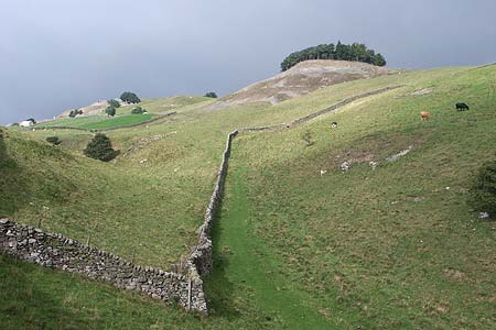
Starting from the bustling centre of Middleton-in-Teesdale this route includes a variety of scenery. The first section takes you along a section of the Pennine Way crossing the flank of Harter Fell from where wide ranging views can be enjoyed. Descending into the Lune Valley the walk continues alongside Grassholme Reservoir before using a section of old railway back to the start.
There are car parks and limited street parking in Middleton-in-Teesdale (Grid ref. NY947254) where a wide range of facilities, including pubs, shops and cafes are available. When parking, please be considerate to others. After parking leave the village by Bridge Street (signposted to Brough) heading south to drop down to cross the River Tees. Climbing up from the river you soon reach a road junction where the B6277 bends left. Almost opposite is a bridleway, which is also the Pennine Way. The bridleway goes to the left of the Kirkcarrion, a hilltop conifer plantation, but we need to bear right and follow the rather feint Pennine Way as it climbs steadily onto the flanks of Harter Fell.
Pass through the wall on the ridge and aim for a ruined barn which you keep on your right. Ahead lies another barn and you should keep to the right. Continue across a number of small fields to reach Wythes Hill Farm (Grid ref. NY921228). From here take the farm access road down to the B6276. Cross over and continue to follow the Pennine Way across field to Grassholme. Turn left and follow the lane across Grassholme Bridge. Reaching the other side of the reservoir, turn left through a gate (Grid ref. NY930215). Follow the path along the shore of the reservoir with a view to Harter Fell across the resrvoir. After about 30 minutes walking, you reach the reservoir dam. Follow the access road uphill from the dam and turn left onto a minor road (Grid ref NY948224).
Stay on this road as far as the first junction (Grid ref. NY953227). Take the footpath on the left and follow this across fields to reach Eller Beck. Go over the beck and continue uphill to Westfield House. Follow their access road to a lane (Grid ref. NY957238) and turn right. Reaching a railway viaduct, climb up and cross the River Lune following the old trackbed for some way towards Middleton. A sign for Middleton directs you to the right at a farm. Continue across the road and follow the path, which follows the River Tees upstream as far as County Bridge where you turn right into Middleton.
Other walks nearby
| Walk 2228 | Romaldkirk Moor | easy/mod | 7.6 miles |
| Walk 3099 | High Force, Low Force and the River Tees | easy/mod | 7.5 miles |
| Walk 2157 | Romaldkirk & Cotherstone | easy | 5.0 miles |
| Walk 2170 | Eggleston & Mickleton from Romaldkirk | easy/mod | 5.8 miles |
| Walk 1553 | Hannah's Meadow, Baldersdale & Brown Rigg Moss | easy/mod | 8.0 miles |
| Walk 3424 | Cronkley Fell from Hanging Shaw | easy/mod | 7.0 miles |
| Walk 3526 | Hanging Shaw, Cronkley Scar, Low Force & High Force | moderate | 12.7 miles |
| Walk 3634 | Catterick Moss & Bollihope Carrs | moderate | 5.6 miles |
| Walk 2469 | Great Allotment & God's Bridge | moderate | 10.2 miles |
| Walk 2393 | Weardale Circular from Westgate | easy/mod | 6.4 miles |
Recommended Books & eBooks
Great Mountain Days in the Pennines
 An inspirational guidebook to 50 classic walks on the rolling Pennine landscape. The graded routes, between 6 and 13 miles in length, cover classic Pennine fells and moorland such as Whernside, Ilkley Moor and Pendle Hill; exploring the North and South Pennines, Yorkshire Dales, Howgills and Dark Peak. Many routes are also suited to fell running.
More information
Pennine Way Map Booklet
 Map of the 270 miles (435km) Pennine Way National Trail, between Edale in the Peak District and Kirk Yetholm in the Scottish Borders. This booklet is included with the Cicerone guidebook to the trail, and shows the full route on Ordnance Survey 1:25,000 maps. This popular long-distance route typically takes three weeks to complete.
More information
Messaging & Social Media
Message Walking Britain and follow the latest news.

Mountain Weather
Stay safe on the mountains with detailed weather forecasts - for iOS devices or for Android devices.