Walk 1013 - printer friendly version
Pen-y-ghent Walk
Author - Lou Johnson
Length - 6.5 miles / 10.6 km
Ascent - 1540 feet / 467 metres
Grade - moderate
Start - OS grid reference SD807726
Lat 54.148858 + Long -2.2969766
Postcode BD24 0HF (approx. location only)
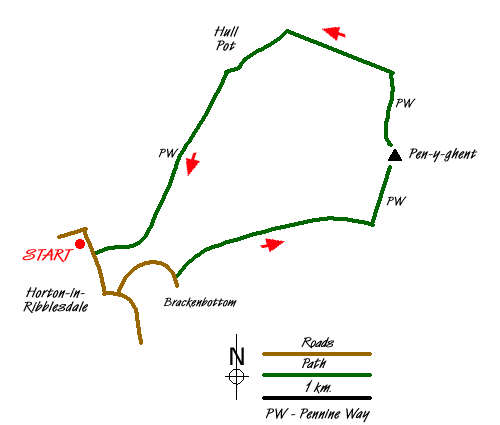
Pen-y-ghent is the lowest mountain of the Yorkshire "Big Three". Its distinctive shape, as a result of its geology, means it is the most easily recognised of the trio. Rising above the village of Horton-in-Ribblesdale, the summit of Pen-y-ghent is crossed by the Pennine Way and offers some fine views across the North Yorkshire countryside and into neighbouring Lancashire. The village of Horton has refreshments (café and pubs) and there are toilets at the main car park. The route via Brackenbottom offers the most direct approach from Horton.
The start of this Yorkshire Dales walk is the pay and display car park (grid ref. SD807726) on the northern outskirts of the village adjacent to the River Ribble. Exit the car park and walk south through the village. Go past the solid looking parish church and turn left off the main road down a lane. A few hundred metres along this lane go right across the footbridge over the stream and turn left up the lane towards Brackenbottom. The lane climbs gently offering improving views of the countryside.
Just before Brackenbottom, take the signed path (Grid ref. SD816722) on your left to Pen-y-ghent. The path climbs in great steps alongside a wall over limestone. As you get higher, the geology changes to gritstone. You reach a cross wall and the Pennine Way (Grid ref. SD836727). Cross the stile and turn left. The path climbs more steeply now with a couple of sections requiring a little use of hands as you ascend the prow of Pen-y-ghent. Soon the gradient eases and you are on the summit plateau with the summit marked with a concrete trig column.
To descend, cross the wall and follow the Pennine Way northwest. This path descends steadily across the western flank of Pen-y-ghent. Where the main path turns sharp left (Grid ref. SD838742), continue ahead on a less defined path that heads for Horton Moor. This section can be a little wet after rain and is the route used by the Three Peak Challenge. The path descends to cross a beck via a plank to reach the main valley path from Foxup.
Turn left along this main path and after a few hundred metres cross the stile on your right to visit impressive Hull Pot. This is particularly impressive when Hull Pot Beck is in spate. From here continue south to regain the main path. Re-joining the main path to and from Pen-y-ghent (Grid ref. SD823743) continue down the walled lane into Horton in Ribblesdale. Reaching the main road, turn right and the car park is a short way along on the left. As you head home you will probably be able to see iconic Pen-y-ghent and happy you have reached its summit.
Messaging & Social Media
Message Walking Britain and follow the latest news.

Mountain Weather
Stay safe on the mountains with detailed weather forecasts - for iOS devices or for Android devices.