Walk 1028 - printer friendly version
Chun Quoit and Botallack Walk
Author - Lou Johnson
Length - 8.0 miles / 13 km
Ascent - 900 feet / 273 metres
Grade - moderate
Start - OS grid reference SW374333
Lat 50.141494 + Long -5.6766491
Postcode TR19 7QE (approx. location only)
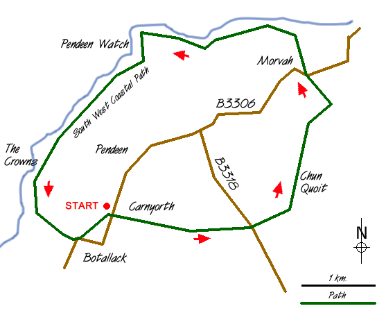
The far west of Cornwall is dominated by Land's End even though there are far more interesting things to see. This Cornwall walk combines Neolithic history, industrial heritage and great scenery yet avoids the crowds. Parking is available in the centre of Carnyorth (Grid ref. SW 374333), which is located on the B3306 St Ives to St Just road.
After parking, taking care not to cause obstruction, head up the lane towards the radio mast to cross a waymarked stile that leads into fields. Cross the fields keeping the mast ahead to reach a track. The views behind you are improving as height is gained. Reaching the mast you will see a tor ahead, Carn Kenidjack, and this is your next objective. Follow the path that leads to the left of this tor and head east, at first on a path and then along a track.
Cross the B3318 and east continue across pleasant moorland. Chun Quoit is a Neolithic tomb and it can be seen to the left of the hill ahead. From the Quoit there are excellent all round views which improve again if you climb to the summit of the hilltop fort of Chun Castle. From the Quoit head north on the clear path with Morvah Church ahead. The path leaves the moor and joins a track, which is followed as far as Carne Farm.
Just before the farmyard take the signed footpath on the left. This leads across fields to reach the main road. Take the path to the right of the church. This path twists down to the sea to reach the coastal footpath where you turn left. Looking east the view is superb with Trevowhan and Trevean cliffs plunging down to the sea. The path drops down to Portheras beach before a steep climb leads you up to Pendeen Watch.
The lighthouse, which provided warning of this dangerous headland, is now open to visitors. Throughout the centuries a great number of ships came to grief in the immediate area and some historians suggest that it was one of the worst places in Cornwall for disasters at sea. Follow the road from the lighthouse to the terrace of cottages that were built to house the lighthouse keepers. Just past the end of the terrace rejoin the coastal path.
Your onward route stays near the cliff tops before winding through the ruins of Levant Mine. The advent of tin mining brought prosperity to the area although the days of profitable enterprise have long since passed. Of interest of the Levant beam-engine, which has been restored by the National Trust and is open for public viewing during the season. Occasionally steamed up it is possible to see this wonderful piece of equipment in operation.
Stay on the coastal footpath to reach a house on your left called Roscommon. There are superb views ahead of cape Cornwall but far below you on the right are the dramatic ruins of the engine-houses at Botallack from where mining extended far out to sea. We leave the coastal path and head inland into the village of Botallack to reach the main road. Turn left along the road and left again through a gap in the cottages to a stile. With the wall on your left continue across fields to reach your starting point.
Messaging & Social Media
Message Walking Britain and follow the latest news.

Mountain Weather
Stay safe on the mountains with detailed weather forecasts - for iOS devices or for Android devices.