Am Bodach and Stob Coire a' Chairn from Kinlochleven
Highland Walk
County/Area - Highland - Fort William Lochaber
Author - Peter Smyly
Length - 9.5 miles / 15.4 km Ascent - 4100 feet / 1242 metres
Time - 8 hours 50 minutes Grade - mod/hard
Maps 

| Ordnance Survey Explorer 384 | Sheet Map | 1:25k | BUY |
| Anquet OS Explorer 384 | Digital Map | 1:25k | BUY |
| Ordnance Survey Landranger 41 | Sheet Map | 1:50k | BUY |
| Anquet OS Landranger 41 | Digital Map | 1:50k | BUY |
Walk Route Description
Click image to visit gallery of 4 images.
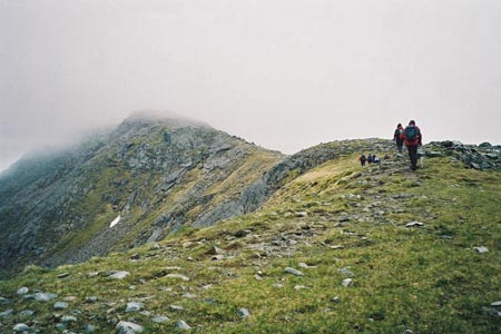
Although this circular walk in the Mamores range includes two of the Munros that form part of the Ring of Steall, walkers wishing to do the horseshoe in either direction are better advised to start from Glen Nevis to the north. Kinlochleven's position to the south does not lend itself to such a traverse unless one is not averse to a certain amount of backtracking up and down high, rugged and rocky mountains that rank among Scotland's finest with some eye-catching scenery of high mountains including. Ben Nevis.
From Kinlochleven, the initial route follows part of the West Highland Way in a north-westerly direction for about a mile. As the path gains altitude, there is a fine view looking back down on Kinlochleven. You need to take a track that branches off to the right. This path leads into a wild valley, Coire na h-Eirghe, between Stob Coire na h- Eirghe and Sgurr an Fhuarain, as it gains height steadily with Am Bodach above on the right. The path leads to a bealach and reveals several of the Mamores peaks. This is a good point to pause for a break before tackling the steep pull up to Am Bodach. The summit area of Am Bodach may not be the most memorable, but the narrow steep ridge leading to its top and the descent that follows is likely to be more so. Mountains can create different impressions in the minds of walkers and in the case of Am Bodach, the final ascent from the bealach between it and Sgurr an Lubhair is, in the latter stages so steep that the mountain seems much higher than it actually is. I would offer one word of warning regarding this walk, however, and that is, that the descent from Am Bodach down to the next dip is one where particular care needs to be taken, even in good weather conditions, for not only is it steep but there are loose stones and rocks aplenty and just one lapse of concentration or misplaced footstep could dislodge one of them.
By way of contrast, the walk up to Stob Coire a Chairn is relatively easy and straightforward up a grassy slope with a more or less level summit area marked by a small pile of stones. Attention is drawn to the next peak in the horseshoe to the north-east, An Garbhanach which offers a tempting, though steep and rocky prospect for the next summit if it is decided the route should follow this direction. Binnein Mor and Na Gruagaichean also loom large to the east across the valley. If descending to Kinlochleven, a path now heads more or less due east, then south-east and skirts the lower slopes of Na Gruagaichean before doubling-back to reach the upper regions of Coire na Ba with Am Bodach now towering above across the valley ahead. The path leads down to the Mamore Lodge (Hotel) and back down to Kinlochleven and the start point of the walk.
Other walks nearby
| Walk 1496 | WHW - Day 6 - Kinlocheven to Fort William | moderate | 15.0 miles |
| Walk 2554 | The Lost Valley, Glen Coe | easy/mod | 4.2 miles |
| Walk 3251 | Bidean nam Bian via Stob Coire nan Lochan, Glencoe | hard | 5.0 miles |
| Walk 2808 | Buachaille Etive Beag, Glen Coe | hard | 9.0 miles |
| Walk 2955 | Ridges & peaks of Bidean Nam Bian | very hard | 10.5 miles |
| Walk 2819 | Stob na Broige, Buchaille Etive Mor, Glen Coe | mod/hard | 6.1 miles |
| Walk 3010 | Stob Dearg (Buachaille Etive Mor) from Altnafeadh | mod/hard | 4.0 miles |
| Walk 3269 | The Munros of Buachaille Etive Mor | mod/hard | 8.2 miles |
| Walk 3303 | Mamores Ridge - Stob Ban, Am Bodach and Sgurr an Iubhair | hard | 9.0 miles |
| Walk 3095 | Stob Ban (Mamores) | mod/hard | 6.0 miles |
Recommended Books & eBooks
Skye's Cuillin Ridge Traverse
 This 2-volume set provides all the information required to complete the main ridge traverse on Skye's Black Cuillin. Strategy, gear, training, navigation and logistics are covered, and 10 classic scrambles are described. A lightweight second guidebook gives the scrambler detailed maps, topos and route description for the ridge traverse itself.
More information
Walking the Munros Vol 2 - Northern Highlands and the Cairngorms
 Guidebook to walking the northern Munros, covering the northern Highlands, the Cairngorms and the Isle of Skye. 70 routes are described, including those up Ben Macdui, Braeriach and Cairn Gorm. Routes range from 7 to 46km, requiring a fair level of fitness. The second of two guidebooks to walking Scotland's Munros: peaks higher than 3000ft.
More information
Messaging & Social Media
Message Walking Britain and follow the latest news.

Mountain Weather
Stay safe on the mountains with detailed weather forecasts - for iOS devices or for Android devices.