Wye and the Crundale Downs
Kent Walk
County/Area - Kent
Author - Peter Smyly
Length - 9.2 miles / 15 km Ascent - 900 feet / 273 metres
Time - 5 hours 30 minutes Grade - moderate
Maps 

| Ordnance Survey Explorer 137 | Sheet Map | 1:25k | BUY |
| Anquet OS Explorer 137 | Digital Map | 1:25k | BUY |
| Ordnance Survey Landranger 189 | Sheet Map | 1:50k | BUY |
| Anquet OS Landranger 189 | Digital Map | 1:50k | BUY |
Walk Route Description
Click image to visit gallery of 6 images.
The North Downs Way extends for 156 miles between Farnham and Dover. The Crundale Downs are located towards the south eastern end of the route. In old English, Crun means chalk and dale means valley which gives a good idea of the chalk downland covered by the walk. Scenery typically consists of distant low tree-clad ridges with grassy slopes and fields, hedgerows, woodland and isolated buildings lower down. The walk is particularly pleasant on a bright summer's day when idyllic views are enhanced in places by sweeping distant vistas including vast wheat fields. Colourful flowers may be seen, especially the orange/red poppy, while some thistles with purple flowers can grow as tall as six feet or more. The Devil's Kneading Trough, a dry valley, is included. The route passes close to Wye Crown, along the edge of an escarpment and the ridge of the Crundale Downs. Wye Crown itself is a chalk crown that has been cut out of the side of the ridge overlooking Wye, seen to good effect from afar, but this walk only offers a glimpse of it from above. The route passes through some woodland stretches where views are either limited or else not at all, but on a hot summer's day, the shade offers some temporary respite from the heat and the sun. In any case, the next view is usually not far away. Paths are not all way-marked and a map and compass are advisable. The landscape is very dry, therefore don't expect to see any streams or ponds. The route is mainly a circular one with a slight "out and back" digression to visit the Devil's Kneading Trough. There are various paths, bridleways and secondary roads that join up, therefore a route can be varied as you go along.
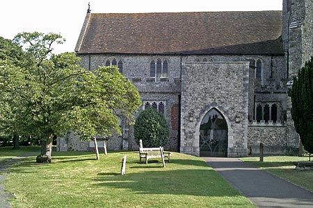
Starting at Wye railway station, cross the bridge over the River Stour, passing the Tickled Trout pub on the left. Take the first road on the left which curves round to the right and passes a village green on the left. Next follow a public footpath sign on the left, indicating a route which goes past the church and along a narrow path with a field on the left and a hedgerow on the right. At this point, the view of the downs across the valley to the west is apparent. At the end of the path, follow the road to the right and ahead at the crossroads to continue along Occupation Road, passing allotments and Steve Bloom Images on the right. The road becomes a bridleway that borders a field on the left leading to a crossroads where it meets up with a secondary road. This point is returned to in the latter stages of the walk. Keep straight on as a path heads up to and through woodland as height is gained. The area just before the woods is shown on Streetmap as "The Junipers". Looking back, the church at Wye can be glimpsed above tree-tops. In the woods, a permissive path via Wibberley Way offers a short cut to the main ridge on the right, but this route is only slightly longer and follows sign posts for the North Downs Way. The path emerges onto a road where a right turn through woodland leads to a point where the road starts to emerge into the open. At this point, a sign post to the right indicates the continuation of the North Downs Way and another sign says that Wye Crown is a quarter of a mile from here. Once the ridge of Wye Crown has been reached, you are now on the main crest of the downs with the best view so far towards Wye and beyond. The Wibberley Way permissive path is also seen to the right where it emerges from the woods.
The route now follows the crest of the ridge to the south-east with an open aspect on the right with occasional bowl-shaped depressions and a barbed wire fence on the left. Go as far as a road where a sign post indicates the continuation of the North Downs Way across another road where a path enters woodland, signposted for the Devil's Kneading Trough (which is not named on the Ordnance Survey map) in another a quarter of a mile. The walk later returns to this point as this is an "out and back" section of the route. This dry valley is one of Kent's better-know natural landscape features, with its steep grassy sides and a flat grassy bottom. Public access is denied to the valley itself, but it can be clearly seen from the grassy ridge above. Yellow warning signs explain that there is unexploded ordnance in the area. A path to the right goes gently down a grassy ridge to a viewpoint.
A nearby car park and restaurant offer a possible lunch stop. To continue this walk, return to the point where the route left the crest of the downs a quarter of a mile back and now take the secondary road on the right down towards Coombe Farm to the north east. On approaching the farm, take the next public footpath, a wide grassy path to the right just before the farm. The path leads uphill towards a wood. However, instead of going through the metal gate into the wood, take a less obvious path over a kind of wooden stile on the left just before the wood, a route that leads briefly through a tree-filled depression before emerging via a gate into the open. Here the route borders Hurst Wood on the left while following a vague track across a grassy field with flowers, thistles and nettles to go through a gate at the far end of the field leading to a crossroads. Go straight ahead here and for about the next half a mile, views are largely obscured by trees, in summer at least, The view opens out on the right before doing so on both sides as a double-rutted farm track leads to a car park at Crundale Church. Views from here both to west and east rank among the better ones on the whole walk and a wooden seat provides a convenient stopping point.
It is not necessary to go into the village of Crundale itself to complete the route. Instead, a sign posted public byway on the left, off the tarmac road to the north of Crundale Church leads down to the bottom of the valley. The route passes some houses on the right before heading up towards Warren Wood where tree-felling activities may be taking place, in which case the safer option is to continue to the next road. This point on the walk brings another fine landscape view towards the downs to the west. Turn left to continue down the lane which is narrow and steep-sided in places with limited space to step aside in the event of oncoming traffic. Ignore a padlocked metal gate on the left. The point where you rejoin the woods on the left is where the road turns to the right. Now a path heads up steeply through woodland. Turn right at a T. At the next crossroads of paths, you need to leave the main path and take a less obvious grassy path down to a metal gate on the right (south west). Although not waymarked at this point, this continuation of the walk is along part of the Stour Valley route which is joined at the crossroads and is shown as "Ash" on Streetmap. Now the route crosses a couple of fields before going down steeply through Beech Wood. It emerges into the open to follow a path through a sloping wheat field. The path then borders the next wood, to the right of it, before taking a sharp left through trees to reach a road. Turn right here and then left and you find that after a few hundred yards you have rejoined the earlier part of the walk where you joined a crossroads. Now return to the start point of the walk by reversing this part of the route.
Other walks nearby
| Walk 2444 | Wye, Crundale & Wye Downs | moderate | 8.6 miles |
| Walk 3617 | The Wye Downs and Crundale | easy/mod | 6.0 miles |
| Walk 1353 | Pluckley village circular | easy | 3.7 miles |
| Walk 3219 | Canterbury to Whitstable | easy/mod | 10.5 miles |
| Walk 1637 | Rivers Swale & Oare | easy | 5.0 miles |
| Walk 3326 | Ringlestone & High Wood from Harrietsham | easy/mod | 8.0 miles |
| Walk 2923 | Folkestone to Dover along the North Downs Way | easy/mod | 8.2 miles |
| Walk 3521 | Wittersham to Rye (High Weald Landscape Trail) | easy/mod | 7.5 miles |
| Walk 2249 | Reculver & St Nicholas at Wade | easy/mod | 8.2 miles |
| Walk 3756 | Rye Harbour Circular | easy | 6.0 miles |
Recommended Books & eBooks
Walking in Kent
 A guidebook describing 40 walks in the county of Kent. Covering west Kent and The Weald and north and east Kent, including the Kent Downs and the Greensand Hills. Walks of 5 to 9 miles explore rivers and coastline, beautiful countryside and historic villages. With outlines of 11 longer walks ranging from 15 to 163 miles.
More information
Messaging & Social Media
Message Walking Britain and follow the latest news.

Mountain Weather
Stay safe on the mountains with detailed weather forecasts - for iOS devices or for Android devices.