Walk 1055 - printer friendly version
Penhill & West Burton Walk
Author - Lou Johnson
Length - 10.0 miles / 16.3 km
Ascent - 1500 feet / 455 metres
Grade - moderate
Start - OS grid reference SE011887
Lat 54.293919 + Long -1.9846021
Postcode DL8 3TH (approx. location only)
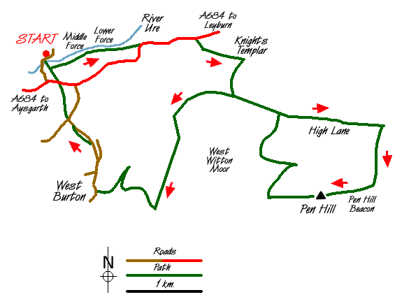
Wensleydale, unlike most other dales, is not named after the river that runs through it. This Yorkshire Dales walk visits a superb series of waterfalls on the River Ure and then continues to Pen Hill, which offers fine views across the dale before returning via the attractive village of West Burton. The start is the large car park adjacent to the National Park Centre (Grid ref. SE 011887) near Aysgarth Falls. This car park can be reached from the A684 Leyburn to Hawes road from just east of Aysgarth village.
From the car park exit south to the River Ure and cross the road bridge from where there are views on your right to High Force. On reaching the south bank of the river leave the road and follow the path to the church. Turn left and take the signed path to reach the river bank and views of Middle and Lower Force. More dramatic after heavy rain they are still an impressive sight in drier weather. Continue on the path to reach the A684. Sadly this road has become very busy in recent years and you need take care as you head east towards Leyburn.
Just before Temple Farm (Grid ref. SE 032889) turn right along a signed right of way. This leads after a short climb through woodland to the Knights Templars' Chapel where several interesting graves can be seen. After visiting this historic site return to the right of way and continue to a gate (Grid ref. SE 039886). Do not follow the path heading east instead turn right and follow the track south keeping the wall on your left. This leads to High Lane. Turn left and continue on this walled lane for two kilometres to a point where a path crosses the lane (Grid ref. SE 059877). Turn right here and ascend through fields to reach Flint Lane.
Go straight over this track and continue climbing to reach the main path that heads west to Penhill Beacon. Turn west (right) and continue to the Beacon from where you have superb views over Wensleydale. Following the path along the edge, which should be on your right, continue to Black Scar (Grid ref. SE 043867). The path is about 150 metres short of the second wall after leaving the trig point. Should you miss this path then descend alongside this second wall (Grid ref. SE 041866) trending northeast to locate the path that leads down to a wall (Grid ref. SE 043872). The onward path descends steadily to reach High Lane (Grid ref. SE 044879).
Turn left along the walled lane and continue until you reach Morpeth Scar. Ignore the lane descending the escarpment instead forking right in a southerly direction and climbing steadily to reach Hudson Quarry. Just before the quarry turn right down a signed footpath following this down the escarpment into the attractive village of West Burton. A popular place with car-bound visitors refreshments are available here and a short visit to the waterfalls adds further interest to the walk.
Leave West Burton on the main road heading north to the A684. At the road junction (Grid ref. SE 019872) take the left fork - Eshington Lane. The footpath runs in an adjacent field parallel with the road for s short distance before reaching Eshington Bridge. Where the road bends right locate the signed footpath on your left. Ascent at the end of a walk is never welcome and the climb is short and sweet with the A684 soon reached. Cross over the main road and follow the footpath past the church and down to the River Ure. Access to the car park is on your left.
Messaging & Social Media
Message Walking Britain and follow the latest news.

Mountain Weather
Stay safe on the mountains with detailed weather forecasts - for iOS devices or for Android devices.