Walk 1062 - printer friendly version
Pusey & Buckland circular Walk
Author - Visit Southern Oxfordshire
Length - 3.5 miles / 5.7 km
Ascent - 100 feet / 30 metres
Grade - easy
Start - OS grid reference SU344980
Lat 51.679717 + Long -1.5038662
Postcode SN7 8QS (approx. location only)
This short walk explores the area to the west of Faringdon and includes typical landscapes of this area. The walk uses well defined paths and tracks taking you to the village of Pusey. The return route includes the opportunity to see a fine restored dovecote and Buckland House. A longer version of this route can be found at Walk 1063
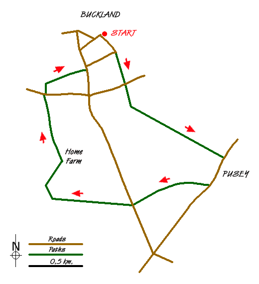
1 - Start at the large car park at Buckland Memorial Hall. Turn right and walk downhill. At the end of the road, take the bridleway straight ahead along the edge of a field.
2 - At the main road (A420) cross the road to a gateway slightly to the right. This is a very busy road, with poor visibility to the right. It may be better to walk along the verge to the right to improve sight of oncoming traffic.
3 -Cross a stile, and walk along a slightly raised path, with a hedge on your right. Proceed for about 150 metres and then fork left diagonally (waymarked) across two fields following overhead cable lines. At the edge of the field, the path leads over two stiles into a small copse. Through the trees, continue along a track in the same direction as before, to a gate onto the B4508 road.
4 - At the road, turn right and walk through Pusey village (or turn left and walk for 150 metres to see Pusey House, and return).
5 - After following the road for around 300 metres, take the bridle path to the right, and follow this between a double fence and through a copse, continuing along the field path to a road.
6 - Cross the road and continue along the track, which continues alongside woodland (Buckland Warren) until you reach a junction of tracks.
7 - At the junction of tracks, turn right with woodland to the left and a field on the right. Keep right at the next intersection and walk through a marshy copse, passing a large and beautifully restored stone dovecot on the right and farm buildings (Home Farm) on the left. Continue along the track until you reach the road (A420).
8 - At the main road, cross with care and take the path opposite through stone gateposts. Go past the lodge and take a stile on the right. Take the path, bearing right, across the field to another stile into woodland. Look to the left to see Buckland House. Follow the path through woodland to the road and turn left. Walk until you see The Lamb public house on your left. Turn right opposite the Lamb and follow the road back through the village to the starting point.
Messaging & Social Media
Message Walking Britain and follow the latest news.

Mountain Weather
Stay safe on the mountains with detailed weather forecasts - for iOS devices or for Android devices.