Haystacks from Honister Pass
Lake District Walk
Nat Park - Lake District - Lake District Western Fells
Wainwrights - Haystacks
County/Area - Cumbria
Author - Lou Johnson
Length - 5.5 miles / 8.9 km Ascent - 1700 feet / 515 metres
Time - 4 hours 30 minutes Grade - moderate
Maps 

| Ordnance Survey Explorer OL4 | Sheet Map | 1:25k | BUY |
| Anquet OS Explorer OL4 | Digital Map | 1:25k | BUY |
| Ordnance Survey Landranger 90 | Sheet Map | 1:50k | BUY |
| Anquet OS Landranger 90 | Digital Map | 1:50k | BUY |
Walk Route Description
Click image to see photo description.
Haystacks, despite its relatively lowly stature (597 m.), was a favourite haunt of Wainwright. Surrounded by many high fells and with views to many of the other major peaks in Lakeland, Haystacks is a very worthwhile objective for a half day Lake District walk.
The start is the top of Honister Pass (Grid ref. NY 225135) where there is a car park near the slate mine and some limited roadside parking. Honister Pass also benefits from a limited bus service. From the car park walk alongside the road towards Buttermere passing the slate factory on your left. The path exits left and climbs immediately leading you onto the old trackbed of a quarry incline. You have over 500 feet of ascent before the incline begins to descend reaching an old quarry building at Dubs Quarry.
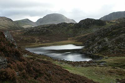
The path goes to the left of the building and descends half left to cross a stream, which can be difficult to cross after heavy rain. Once across the stream the path begins to climb again weaving through a rocky landscape with excellent views of Buttermere to your right. Still climbing you pass Blackbeck Tarn on your left before reaching the shores of Innominate Tarn. Skirting the northern shore the path continues to the summit of Haystacks.
The summit of Haystacks deserves some time. It is a fascinating place to be with many simple scrambles to keep you busy, a small tarn and excellent views. To the west you have the High Stile Ridge, Buttermere and Crummock Water, and the Grasmoor massif whilst in other directions there is a vast array of fells including Great Gable, Scafell Pike, Pillar and Helvellyn. Once you have enjoyed the views return by the same route making sure you have enough energy for the climb from Dubs Quarry to the summit of the incline.
Other walks nearby
| Walk 1114 | Scafell Pike via Corridor Route | hard | 9.5 miles |
| Walk 1236 | Styhead Tarn and Seathwaite Fell | moderate | 7.0 miles |
| Walk 1306 | Base Brown & Great Gable | mod/hard | 6.0 miles |
| Walk 2046 | Great End via the north west face from Seathwaite | very hard | 7.0 miles |
| Walk 1826 | Green Gable & Gillercomb Horseshoe | moderate | 5.5 miles |
| Walk 1692 | Great End & Glaramara from Seathwaite | mod/hard | 7.7 miles |
| Walk 3130 | Scafell Pike via Esk Hause from Seathwaite | mod/hard | 8.0 miles |
| Walk 3096 | Glaramara & Allen Crags from Seathwaite | moderate | 8.1 miles |
| Walk 2182 | Styhead Tarn & Sprinkling Tarn from Seathwaite | moderate | 5.6 miles |
| Walk 1245 | Castle Crag & Grange | easy/mod | 6.0 miles |
Recommended Books & eBooks
Walking the Lake District Fells - Keswick
 Part of the Walking the Lake District Fells series, this guidebook covers a wide range of routes to 30 Lakeland summits that can be climbed from Keswick, Whinlatter, Bassenthwaite, Caldbeck, Mungrisdale and Threlkeld, with highlights including Skiddaw and Blencathra. Includes suggestions for longer ridge routes.
More information
Walking the Lake District Fells - Langdale
 Part of the Walking the Lake District Fells series, this guidebook covers a wide range of routes to 25 Lakeland summits that can be climbed from the Great Langdale valley, Ambleside and Grasmere, with highlights including Scafell Pike, Bowfell, the Langdale Pikes and Helm Crag (the Lion and the Lamb). Includes suggestions for longer ridge routes.
More information
Messaging & Social Media
Message Walking Britain and follow the latest news.

Mountain Weather
Stay safe on the mountains with detailed weather forecasts - for iOS devices or for Android devices.