Mam Tor & Cave Dale Walk
Walk 1087 - Route Maps & Profile
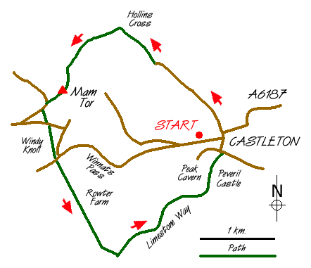
Route Map
Digital Maps - Copyright © 2011-2024. All rights reserved.
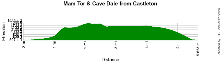
Route Profile
Sketch Map
Suggested Maps 

| Ordnance Survey Explorer OL1 | Sheet Map | 1:25k | BUY |
| Anquet OS Explorer OL1 | Digital Map | 1:25k | BUY |
| Ordnance Survey Landranger 110 | Sheet Map | 1:50k | BUY |
| Anquet OS Landranger 110 | Digital Map | 1:50k | BUY |
It is recommended you take a map. The preferred scale is 1:25k.
Start Point Details
Ordnance Survey Grid Ref SK149829
Latitude 53.342791 Longitude -1.77767
Postcode S33 8WN
what3words start squaring.washed.inferior
Walk description may contain detailed information on the start point for this walk.
Further Information
Peak District
Walking in the Peak District is some of finest in the UK. The National Park suffers from a split personality with its contrasting White and Dark Peaks. Within easy distance from Manchester, Sheffield and the Midlands there is much for the visitor to see. The contrast between quiet limestone dales and wild upland moors provides the basis for a diverse range of Peak District walks with scenic variety the keynote. Peak District Walking Guide
Derbyshire
Derbyshire has a wide range of walking to suit all abilities. The best walks are within the boundaries of the Peak District National Park with the limestone dales of the White Peak and wild gritstone moors of the Dark Peak. Outside of the National Park there is still much of interest to walkers with pleasant rural countryside often with similar characteristics to the area within the National Park boundaries.
Walk grading - Learn how each walk is assessed and select a walk to suit your ability and experience by going to Walk Grading Details.
Messaging & Social Media
Message Walking Britain and follow the latest news.

Mountain Weather
Stay safe on the mountains with detailed weather forecasts - for iOS devices or for Android devices.