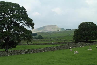
Pen-y-ghent & Plover Hill from Horton in Ribblesdale
Yorkshire Dales Walk
Nat Park - Yorkshire Dales - Three Peaks Country
County/Area - North Yorkshire
Author - Lou Johnson
Length - 9.0 miles / 14.6 km Ascent - 1760 feet / 533 metres
Time - 6 hours 20 minutes Grade - moderate
Maps 

| Ordnance Survey Explorer OL2 | Sheet Map | 1:25k | BUY |
| Anquet OS Explorer OL2 | Digital Map | 1:25k | BUY |
| Ordnance Survey Landranger 98 | Sheet Map | 1:50k | BUY |
| Anquet OS Landranger 98 | Digital Map | 1:50k | BUY |
Walk Route Description
Click image to visit gallery of 4 images.
Pen-y-ghent is one of the famous 'Three Peaks' of Yorkshire with a distinctive shape especially when seen from the south west approach. Often busy this Yorkshire Dales walk combines a visit to the summit with a quieter ridge and valley walk to complete the excursion. The walk starts in the village of Horton in Ribblesdale well known for its association with the Yorkshire "Big Three".
From the main car park (grid ref. SD807726) walk south along the main road towards the stone-built Norman Parish Church from where there is a good view of the main objective of this walk. Just past the church, cross a stream and turn left along a narrow lane, keeping the stream on your left. The lane soon veers right away from the stream to lead to the small hamlet of Brackenbottom.
Just before the houses, turn left at a public footpath sign for Pen-y-ghent. Stay with this path keeping the wall on your left as you climb steadily through fields with Pen-y-ghent ahead. As you climb the view improves with the smooth outline of Fountains Fell to your right. Apart from a few short sections of very easy scrambling to reach a stile at the foot of the steep escarpment on the southern end of Pen-y-ghent.
The final climb onto the summit plateau is steep but recent path improvements have made the going easier and the summit cairn soon comes into view. As can be expected the all-round view is superb with Ingleborough and Whernside (the other two members of the "Big Three") dominating the panorama. Also of note is the view of Ribblesdale to the west and less-known Silverdale to the east.
The normal route of ascent heads off the summit in a north-easterly direction and this can be used for a quicker return to Horton in Ribblesdale. However, as mentioned in the introduction, our route continues along the ridge joining Pen-y-ghent with Plover Hill and this is easily accomplished by following the wall heading roughly north from the summit.
The path follows the west side of the wall and in a few places can be wet and boggy but generally speaking these squelchy patches can be avoided. Stay with the wall all the way to the summit of Plover Hill where there are fine views into Littondale and beyond.
From the summit of Plover Hill cross the wall and head north following a clear path that descends slowly at first. Nearing a stone wall on your right the descent steepens and you drop down dramatically across Foxup Moor to reach a clear path. Turn left and stay with this path heading in the general direction of Horton in Ribblesdale.
The walking in the valley is excellent with good views and you soon reach the magnificent chasm of Hull Pot, which is slightly off route but well worth the short detour. A deep chasm with steep sides it is at its most impressive after heavy rain when water streams down into the cave. From the Pot retrace your steps to the main path and continue along Horton Scar Lane. This very pleasant walled track crosses some fine limestone scenery and leads you easily back to Horton in Ribblesdale. Nearing the village fork right at a junction and continue down to the main road. The car park is a short way along the main road to your right.
Other walks nearby
| Walk 3392 | Darnbrook Fell & Fountains Fell | moderate | 6.4 miles |
| Walk 1251 | The Norber Erratics & Sulber Gate | moderate | 8.0 miles |
| Walk 2620 | Sulber Gate & Crummack Dale from Austwick | moderate | 9.5 miles |
| Walk 2649 | Attermire Scar & Malham Tarn from Stainforth | mod/hard | 16.5 miles |
| Walk 1248 | Trow Gill, Ingleborough & Long Scar | moderate | 9.5 miles |
| Walk 2796 | Ingleborough via Gaping Gill & Norber | moderate | 13.0 miles |
| Walk 3599 | Clapham, Oxenber Woods, Feizor & Settle | easy/mod | 7.5 miles |
| Walk 3094 | Norber & Norber Erractics | easy/mod | 6.3 miles |
| Walk 2617 | Nappa Cross & Victoria Cave from Langcliffe | moderate | 9.5 miles |
| Walk 1404 | Oxenber and Wharfe Woods from Langcliffe | moderate | 10.5 miles |
Recommended Books & eBooks
The Pennine Way
 Guidebook to the Pennine Way National Trail with OS map booklet. The 265 mile route from Edale to Kirk Yetholm takes three weeks to walk and is suitable for fit and experienced long distance walkers. The route crosses the Peak District, Yorkshire Dales and North Pennines National Parks. Includes separate OS 1:25,000 map booklet of the route.
More information
Pennine Way Map Booklet
 Map of the 270 miles (435km) Pennine Way National Trail, between Edale in the Peak District and Kirk Yetholm in the Scottish Borders. This booklet is included with the Cicerone guidebook to the trail, and shows the full route on Ordnance Survey 1:25,000 maps. This popular long-distance route typically takes three weeks to complete.
More information
Messaging & Social Media
Message Walking Britain and follow the latest news.

Mountain Weather
Stay safe on the mountains with detailed weather forecasts - for iOS devices or for Android devices.