Walk 1138 - printer friendly version
The Ridgeway at Chequers Walk
Author - Donald Morton
Length - 7.3 miles / 11.8 km
Ascent - 800 feet / 242 metres
Grade - easy/mod
Start - OS grid reference SP857040
Lat 51.728177 + Long -0.76056462
Postcode HP16 9PS (approx. location only)
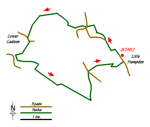
This walk starts Little Hampden, about 2.5 miles NW of Great Missenden, where there is a small place for parking (Grid Ref SP857040). The village is at the end of the lane so you can have arrived by car from only one direction. Start the walk by continuing in the same direction. Once past the former pub (peep under the veranda to see the Rising Sun sign) the lane turns to gravel. At a fork bear left, signed S Bucks Way, and then at cross tracks turn left. This soon brings you to an open field where you turn right along the field edge, now signed the Icknield Way (Not part of the original prehistoric track but an extension from Ivinghoe to Bledlow.) Go right through double metal five bar gates to reach a multi track junction. Go half left, the second left hand track, again signed the S Bucks Way. At a T-junction turn right and follow to a cross track where you join part of the Ridgeway, the track which runs in total from Ivinghoe Beacon to the N Wessex Downs. The Ridgeway is easy to follow being well signed either with the specific name or an acorn logo.
Turn left here on a broad track which descends to a lane. Go straight across the lane to a bridle gate beside a five bar gate. Smile nicely for now you may be on camera as you enter the Chequers estate. The path goes parallel to a single strand wire fence on the right. Not much of a defence - none at all really - but you are warned that it is an offence to cross it. So keep to the left of it but there are good views of the house across the parkland to the right. At the end of this stretch you are on camera again as you cross one of the main drives to a bridle gate leading into an arable field. A clear path leads diagonally right uphill to a wood; again there is a single strand wire fence not to be crossed on the right. After entering the wood immediately turn right along the edge. A little further on there are again views of Chequers over to the right sitting in its parkland. Exit the woods via a bridle gate and the path continues straight on over an open grassy area. As you rise up the hill a set of multiple gates come into view where Ridgeway signs confirm you are on the right track.
From here there are wonderfully panoramic views over the plains of Oxfordshire and S Bucks. (For the first time the cooling towers of Didcot power station can be seen on the horizon and if one walks the Ridgeway North-South they will now be a frequent part of the view until they are passed.) From here the Ridgeway descends on an obvious track to a kissing gate into woods by a magnificent ancient beech tree. One turns right onto an ancient trackway but almost immediately left again to go down to cross the base of an open valley. There is now a stretch of obvious path across downland, another stretch of woodland before crossing a bridleway to another patch of downland rich in wild flowers, and finally an enclosed path out to a road. Turn left on the road and very soon fork right to pass - or stop at - the Plough PH. At the far end of the Plough turn right and follow the Ridgeway up to the top Whiteleaf Hill where there is a Neolithic burial mound and 180 degree views again over Oxfordshire and Bucks. At the finger post turn left still following the Ridgeway. Once through the gate the path becomes very made.
In a short distance leave the Ridgeway by turning left down the first bridleway on the left, the Icknield Way. This soon reaches the edge of the forest and follows the edge until a T-junction is reached, where the Icknield Way turns left and you turn right, again along the forest edge. This track eventually emerges at cross tracks. Turn left, again along the forest edge but now outside the forest boundary. When this track enters the woods go straight on, ignoring all side paths. It is undulating, and at the end gently uphill to cross over two wide tracks. After the second it becomes flatter; it goes over a crossing footpath - marked by a redundant stile - and starts running alongside the vestiges of a bank and ditch - one of the many Iron Age constructions bearing the name Grimms Ditch. It emerges from woodland to continue straight on down a field edge. At the end of the field go straight on down a gravel track. Do not follow this round to the right but turn off left through gates. Proceed down a grassy avenue with an imposing mansion ahead, Hampden House, the remodelled home of John Hampden, a leading figure on the parliamentary side of the English Civil War.
Just before this is reached join the Chiltern Way by turning left over a stile. You follow the Chiltern Way right through to Little Hampden, initially across a field to a track through woods. This descends and when it leaves the woods goes across an arable field to the far corner. Cross the road and go straight on along and up a woodland path and on to the village green in Little Hampden. Here a left turn along the lane brings you back to the car park.
Messaging & Social Media
Message Walking Britain and follow the latest news.

Mountain Weather
Stay safe on the mountains with detailed weather forecasts - for iOS devices or for Android devices.