Buttermere Circular
Lake District Walk
Nat Park - Lake District - Lake District North Western Fells
County/Area - Cumbria
Author - Lou Johnson
Length - 4.5 miles / 7.3 km Ascent - 100 feet / 30 metres
Time - 2 hours 20 minutes Grade - easy
Maps 

| Ordnance Survey Explorer OL6 | Sheet Map | 1:25k | BUY |
| Anquet OS Explorer OL6 | Digital Map | 1:25k | BUY |
| Ordnance Survey Landranger 90 | Sheet Map | 1:50k | BUY |
| Anquet OS Landranger 90 | Digital Map | 1:50k | BUY |
Walk Route Description
Click image to visit gallery of 3 images.
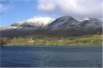
With virtually no ascent on the 4.5 mile circuit, this is an ideal Lake District walk for those who wish to spend some time among the mountains yet not expend too much energy! After some overnight snow and storm force winds on the fells, we opted to stay at low level. Starting from the small car park (grid ref. NY 173169) alongside the Fish Hotel, we set off along the south-western shore of this beautifully situated lake, taking time to admire the wonderful mountain vistas all around us.
On the outward leg towards Warnscale Bottom Fleetwith Pike dominated the scene ahead with Hay Stacks looking an interesting mass of craggy outcrops. To our left the crags of Littledale Edge, linking Dale Head with Robinson, looked wonderful with patches of snow adding interest to the fellside. On our right the high mountains of the High Stile ridge soared upwards whilst behind us the upland mass of Grasmoor and the instantly recognisable shape of Mellbreak completed the picture.
Crossing Peggy's bridge we made for Gatescarth farm (parking is available here) to reach the road coming down from Honister Pass. After a short section of tarmac, we were back on the lakeside path, able to concentrate on Mellbreak and the depths of Burtness Combe high on the slopes of High Stile. All too soon we were back in Buttermere after an easy but scenic two hour stroll around the lake.
Other walks nearby
| Walk 2642 | Buttermere Horseshoe | very hard | 14.0 miles |
| Walk 2539 | Grasmoor and Rannerdale Knotts | moderate | 8.0 miles |
| Walk 1732 | Coledale and Newlands circular from near Buttermere | hard | 9.0 miles |
| Walk 1011 | Knott Rigg and Ard Crags | easy/mod | 3.5 miles |
| Walk 1231 | Grasmoor via Whiteless Pike | moderate | 7.0 miles |
| Walk 2020 | Rannerdale Knotts and Crummock Water from Cinderdale Common | easy/mod | 2.5 miles |
| Walk 1153 | The High Stile Ridge | hard | 10.0 miles |
| Walk 1289 | Fleetwith Pike & Haystacks | moderate | 5.5 miles |
| Walk 2021 | Whiteside, Hopegill Head & Grisedale Pike | moderate | 7.5 miles |
| Walk 3676 | Hen Comb from Loweswater | moderate | 5.4 miles |
Recommended Books & eBooks
Walking the Lake District Fells - Keswick
 Part of the Walking the Lake District Fells series, this guidebook covers a wide range of routes to 30 Lakeland summits that can be climbed from Keswick, Whinlatter, Bassenthwaite, Caldbeck, Mungrisdale and Threlkeld, with highlights including Skiddaw and Blencathra. Includes suggestions for longer ridge routes.
More information
Walking the Lake District Fells - Buttermere
 Part of the Walking the Lake District Fells series, this guidebook covers a wide range of routes to 32 Lakeland summits that can be climbed from the Buttermere, Lorton and Newlands valleys, with highlights including Haystacks, High Stile, Grasmoor and the fells of the Coledale Round. Suggestions for longer ridge routes are also included.
More information
Messaging & Social Media
Message Walking Britain and follow the latest news.

Mountain Weather
Stay safe on the mountains with detailed weather forecasts - for iOS devices or for Android devices.