Hallin Fell from Martindale Church, Sandwick
Lake District Walk
Nat Park - Lake District - Lake District Far Eastern Fells
Wainwrights - Hallin Fell
County/Area - Cumbria
Author - Lou Johnson
Length - 2.0 miles / 3.3 km Ascent - 400 feet / 121 metres
Time - 1 hours 20 minutes Grade - easy
Maps 

| Ordnance Survey Explorer OL5 | Sheet Map | 1:25k | BUY |
| Anquet OS Explorer OL5 | Digital Map | 1:25k | BUY |
| Ordnance Survey Landranger 90 | Sheet Map | 1:50k | BUY |
| Anquet OS Landranger 90 | Digital Map | 1:50k | BUY |
Walk Route Description
Click image to visit gallery of 2 images.
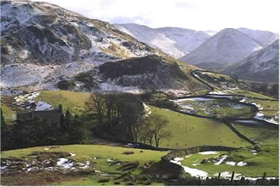
Not the most demanding Lake District fell walk but ideal with gale to storm force icy winds sweeping across the mountains. Described by Wainwright as a "motorists fell" it is an easy stroll to the summit of Hallin Fell (1272ft 388m) from the small car park (grid ref. NY 435191) adjacent to St Peter's church. Climbing in perfect light and visibility was easy on the lee side of the fell and the strength of the wind was not felt until the summit was neared. The last few yards had to be completed on hands and knees as the wind threatened to send us down into Martindale.
The summit cairn is a sturdy piece of stonework and provided enough shelter to admire the extensive views across the Lake District. Despite Hallin Fell's lowly stature, almost the whole of Ullswater can be seen, flanked on all sides by higher fells. We could see the snow being blown off Helvellyn and the other high tops to the west. Nearer to hand the fells of the High Street range shimmered with snow which had fallen the previous night. Away to the east the white tops of the Pennines could be easily seen in the clear cold air.
No detailed description of the walk is necessary. After parking by the church, follow your nose upward over pleasant grassy paths to the cairn. If time permits spend a few minutes to visit St Peter's Church - what a beautiful location for worship!
Other walks nearby
| Walk 2039 | Gowbarrow Fell circular | moderate | 3.5 miles |
| Walk 1230 | Birks & Arnison Crag | moderate | 5.5 miles |
| Walk 1520 | Helvellyn & Fairfield Horseshoe from Patterdale | very hard | 13.0 miles |
| Walk 2047 | Place Fell from Patterdale | moderate | 7.5 miles |
| Walk 2425 | Boredale Circular from Patterdale | mod/hard | 11.5 miles |
| Walk 3670 | Angle Tarn and Hayeswater | moderate | 8.3 miles |
| Walk 1156 | Helvellyn via Striding Edge | hard | 9.5 miles |
| Walk 1235 | Red Tarn & Grisedale | moderate | 7.0 miles |
| Walk 1710 | Glenridding, St. Sunday Crag & Helvellyn | hard | 11.5 miles |
| Walk 3232 | Glenridding Dodd & Sheffield Pike | easy/mod | 4.5 miles |
Recommended Books & eBooks
Hadrian's Wall Path
 Hadrians Wall Path guidebook to walk the 84 mile National Trail. Described in both directions, the main description is west to east between Bowness-on-Solway and Wallsend, Newcastle, with extensions to Maryport and South Shields. With extensive historical information related to this World Heritage site and separate 1:25,000 OS map booklet included.
More information
Walking the Lake District Fells - Wasdale
 Part of the Walking the Lake District Fells series, this guidebook covers a wide range of routes to 25 Lakeland summits that can be climbed from the Wasdale, Eskdale and Ennerdale valleys, with highlights including Scafell Pike, Great Gable and Pillar. Suggestions for longer ridge routes are also included.
More information
Messaging & Social Media
Message Walking Britain and follow the latest news.

Mountain Weather
Stay safe on the mountains with detailed weather forecasts - for iOS devices or for Android devices.