Grassington, Mastilles Lane & Conistone Dib
Yorkshire Dales Walk
Nat Park - Yorkshire Dales - Upper Wharfedale
County/Area - North Yorkshire
Author - Lou Johnson
Length - 11.3 miles / 18.3 km Ascent - 1850 feet / 561 metres
Time - 7 hours 30 minutes Grade - moderate
Maps 

| Ordnance Survey Explorer OL2 | Sheet Map | 1:25k | BUY |
| Anquet OS Explorer OL2 | Digital Map | 1:25k | BUY |
| Ordnance Survey Landranger 98 | Sheet Map | 1:50k | BUY |
| Anquet OS Landranger 98 | Digital Map | 1:50k | BUY |
Walk Route Description
Click image to visit gallery of 6 images.
Grassington is the main village in the lower reaches of Wharfedale in the Yorkshire Dales National Park. Retaining much character, despite the gift shops, the village almost has the feel of a town. Although this is a long Yorkshire Dales walk, the miles slip by quickly. The ascent is easy and especially in Consitone Dib passes almost unnoticed.
The easiest place to Park is on the large car park adjacent to the National Park information centre (grid ref. SE 002637). Head north along the road towards the village centre (plenty of pubs and cafes if you need refreshment). Take the main road to Threshfield crossing the River Wharfe as it meanders sedately towards the sea.
At Threshfield turn right along the B6160 towards Kettlewell turning left into Skirethorns Lane after a few hundred yards. Follow this lane, turning right into Wood Lane. The end of the road walking is now in sight. Turn left up the main drive into the Caravan site at Wood Nook continuing through the site to emerge alongside Rowley Beck.
The true nature of the countryside is now evident with outcrops of limestone becoming more frequent. Climbing slowly Height House, an abandoned farm, is soon reached and the path continues westwards to Height Laithe Farm which nestles in the valley.
Care is needed in this area as there are a number of paths near the farm although the next objective, Bordley, is signed. The path loses height quite quickly as it approaches Bordley. Reaching the farm access road turn right along it regaining lost height as you head north. Dropping slightly you reach a hollow. Here you leave the road and follow the wall north to Mastilles Lane to Mastilles Gate.
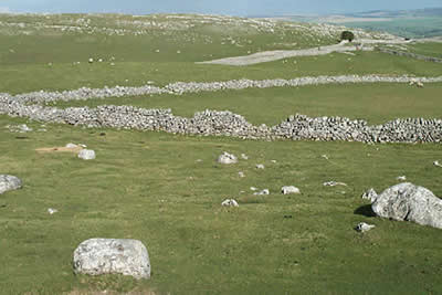
Turn east along the well graded walled lane. You cross wild country - limestone uplands as you cross Kilnsey Moor. Quite suddenly the view ahead opens up across Wharfedale to Great Whernside. You can also clearly see the defile of Conistone Dib immediately behind the village.
With an easy downhill walk you can admire the views staying on the lane until you are under Cool Scar. On the right is a well disguised stile (grid ref. 968673) which leads onto a path down to Bow Bridge Farm. Left on to the main road and right over the Wharfe into Conistone. It is worth looking north from here to the impressive outcrop known as Kilnsey Crag - apparently well favoured by climbers.
A pleasant unspoilt village (no refreshments were found) with cottages grouped together around the small village "green". Leave the road and take the path heading east. This follows the floor of Conistone Dib, a classic limestone gorge, climbing slowly to reach the limestone plateau above. The last section is an easy scramble but should not cause any problems. On reaching the plateau turn immediately right. Do not go through the gate, and follow this path south, ignoring paths descending right.
You are now on the Dales Way (poorly signed in this area) which needs to be followed all the way back to Grassington. To your right and left are excellent examples of limestone pavements. They are very extensive in this area and are certainly equal to those found above Malham. The path splits roughly half way to Grassington (grid ref. SD 996663). The best route is to stay with the wall on your left which eventually leads into a walled lane. Soon you are back in Grassington.
Other walks nearby
| Walk 1292 | Linton & Thorpe Fell & Cracoe | moderate | 9.0 miles |
| Walk 1407 | Thorpe & Burnsall from Linton | easy/mod | 6.2 miles |
| Walk 2610 | Hebden Gill & Cupola Corner | easy/mod | 6.5 miles |
| Walk 2611 | Hebden Gill from Hebden | easy | 4.0 miles |
| Walk 1280 | Trollers Gill | moderate | 9.0 miles |
| Walk 2000 | Wharfedale Circular | moderate | 13.5 miles |
| Walk 1576 | Embsay Reservoir | easy | 1.0 miles |
| Walk 3301 | Conistone to Grassington via the Dib | easy | 5.0 miles |
| Walk 3262 | Copplestone Gate and Conistone Pie from Conistone | easy/mod | 7.0 miles |
| Walk 2423 | Capplestone Gate & Conistone Pie | easy/mod | 6.8 miles |
Recommended Books & eBooks
Trail and Fell Running in the Yorkshire Dales
 Guidebook to 40 of the best trail and fell runs in the Yorkshire Dales National Park. Ranging from 5 to 24 miles, the graded runs start from bases such as Ribblehead, Dent, Sedbergh, Malham and Grassington and take in the region's diverse delights, from castles and waterfalls to iconic mountains such as Whernside, Ingleborough and Pen Y Ghent.
More information
Walking in the Yorkshire Dales: North and East
 This guidebook contains 43 circular day walks in the north and east Yorkshire Dales. It explores the dales, hills and moors between Kirkby Stephen and Pateley Bridge. Walking ranges from gentle 3 mile strolls to more strenuous day-long rambles across the Howgills, Wensleydale, Swaledale, Nidderdale, Mallerstang and Coverdale.
More information
Messaging & Social Media
Message Walking Britain and follow the latest news.

Mountain Weather
Stay safe on the mountains with detailed weather forecasts - for iOS devices or for Android devices.