Between Grasmere and Langdale
Lake District Walk
Nat Park - Lake District - Lake District Central Fells
Wainwrights - Tarn Crag
County/Area - Cumbria
Author - Lou Johnson
Length - 9.5 miles / 15.4 km Ascent - 1820 feet / 552 metres
Time - 6 hours 30 minutes Grade - moderate
Maps 

| Ordnance Survey Explorer OL6 | Sheet Map | 1:25k | BUY |
| Anquet OS Explorer OL6 | Digital Map | 1:25k | BUY |
| Ordnance Survey Explorer OL7 | Sheet Map | 1:25k | BUY |
| Anquet OS Explorer OL7 | Digital Map | 1:25k | BUY |
| Ordnance Survey Landranger 90 | Sheet Map | 1:50k | BUY |
| Anquet OS Landranger 90 | Digital Map | 1:50k | BUY |
Walk Route Description
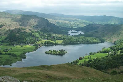
Click image to visit gallery of 3 images.
The high land between Grasmere and Great Langdale is great walking country. Not blessed with any major peaks it more than rewards the walker with excellent views to a large portion of Lakeland and its fells. This Lake District walk was designed to visit three "Wainwrights" - Silver How, Blea Rigg and Tarn Crag which loosely form a horseshoe. The route is on good paths. Apart from the short section down to Belles Knot, all the descents are a pleasure with the final drop from Tarn Crag a pure delight on a wonderful grassy path.
Grasmere is blessed with reasonable car parks and all are convenient starting points for this walk. Leave the village on the lane that skirts the western side of the Lake. Take the walled footpath that leaves the road opposite the cafe (Grid ref. NY334072). This climbs easily along the flanks of Silver How with improving views over Grasmere and Rydal Water. Keep the wall on your left until it bends away to left. Here turn up a steep path on your right (it looks worse than it is) which leads you without any fuss to the cairn on Silver How.
From here the onward route to Blea Rigg falls into place with a well used path twisting and turning as it climbs slowly along the ridge. In some places there are a number of paths to choose from and I would advise keeping to the one that maintains the highest ground. This section of the walk is superb with wide-ranging views on both sides. It does look a difficult task of navigation on the map but it really is a case of following your nose (except in poor visibility when it could be a very confusing place to be). If you have the relevant Wainwright, then his description of the ridge route is very useful.
After Blea Rigg there are excellent views of the Langdale Pikes with Pavey Ark glowering over Stickle Tarn. Care is needed now. The start of the path descending to Belles Knot and Easedale Tarn is not too clear and is only marked with a small cairn. Assuming this junction is found (!) you now have a steep descent on a poor path. Below and to the left hand side of the path is Codale Tarn. You should be making for the eastern shore of this secluded expanse of water. Follow the shore to the northern end. Pass a large boulder and make for a sheepfold, from where a small but distinct path leads upwards to Tarn Crag.
Despite being a "Wainwright" Tarn Crag obviously sees few visits. The paths are excellent, still covered in grass with no evidence of erosion, and the going is easy. It is worth taking your time. The forward view and that down to Easedale Tarn are superb as you gradually descend over Greathead Crag. All too soon you reach a path from Easedale Tarn coming in from the right. Turn left along this to drop gently down to Far Easedale Gill. The remainder of the walk is straightforward, following paths and a lane back into Grasmere.
Other walks nearby
| Walk 3625 | Silver How from Grasmere | easy | 3.2 miles |
| Walk 1472 | Alcock Tarn & Rydal Water | easy/mod | 7.0 miles |
| Walk 1565 | Rydal Water & Grasmere circular | easy/mod | 6.0 miles |
| Walk 1682 | Rydal Water & Grasmere | easy/mod | 5.5 miles |
| Walk 1111 | High Raise & Helm Crag | mod/hard | 9.5 miles |
| Walk 1823 | Fairfield Horseshoe & Loughrigg from High Close | mod/hard | 14.0 miles |
| Walk 2254 | Grisedale Tarn from Grasmere | moderate | 5.5 miles |
| Walk 2841 | Seat Sandal via Grisedale Tarn from Grasmere | moderate | 5.0 miles |
| Walk 2932 | Green Burn horseshoe from Grasmere | moderate | 7.0 miles |
| Walk 2715 | Skelwith Bridge & Loughrigg | easy/mod | 5.5 miles |
Recommended Books & eBooks
Great Mountain Days in the Lake District
 An inspirational guidebook to 50 challenging walks on the high fells of the Lake District. The graded circular routes, between 4 and 14 miles in length, cover classic Lakeland summits like Fairfield, Scafell Pike, Great Gable and Blencathra, to the lesser-known High Spy, King's How and Brund Fell.
More information
Lake District: High Level and Fell Walks
 This guidebook describes 30 graded fell walks on the ridges and high peaks of the English Lake District, the UK's most popular national park. Reaching some of England's finest and highest mountain scenery, this guide leads readers to classic horseshoes and traditional ascents as well as lesser-known routes to quieter summits.
More information
Messaging & Social Media
Message Walking Britain and follow the latest news.

Mountain Weather
Stay safe on the mountains with detailed weather forecasts - for iOS devices or for Android devices.