Walk 1201 - printer friendly version
Black Hag from Kirk Yetholm Walk
Author - Lou Johnson
Length - 8.5 miles / 13.8 km
Ascent - 2110 feet / 639 metres
Grade - moderate
Start - OS grid reference NT827282
Lat 55.547195 + Long -2.2757396
Postcode TD5 8PQ (approx. location only)
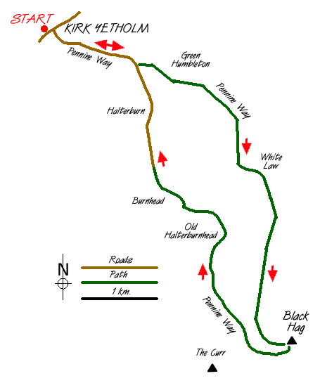
For completeness this walk starts in the village of Kirk Yetholm the northern terminus of the Pennine Way. It combines the high and low level alternative routes for the first (or final) section of this long distance footpath. Despite being very close to England (on the other side of the fence) for some of the way this route stays on Scottish territory for its full length. Ensure you take adequate clothing as there is little shelter along this walk.
Ample parking is available around the pleasant village green in Kirk Yetholm (grid ref NT827282). Take the lane signed to Halterburn climbing out of the village. The lane then descends to a cattle grid where a finger post defines the onward route of the Pennine Way across a footbridge over Halter Burn. The path climbs across the flanks of Green Humbleton to reach the border fence near Stob Rig.
Turn south following the border fence to climb to Whitelaw Nick. From here you get a clear view forward and you realise the terrain is not as easy as you may have imagined. In fact anyone tempted to walk the Pennine Way is well advised to try this walk as it offers a short but valuable insight into the levels of fitness required on this northern section of the path. An unwelcome descent from the Nick is followed by a long steady climb to the summit of Black Hag which is just off the Pennine Way. The summit itself is not very inspiring but there is a fine view into Northumberland as well as a good retrospective of the route covered so far.
Retrace your steps and locate the junction of the high and low level (or good and bad weather!) alternative routes. Take the left fork - a track rather than a path - which descends towards the north. Height is soon lost and you reach Birky Knowe where a finger post provides guidance on the onward route of the path across fields. The lack of path erosion is indicative of the low numbers of people walking this way and solitude is one of the great aspects of walking in this part of Britain. Follow the path past the abandoned farmstead of Old Halterburnhead, which offers the only shelter on this walk, and continue down the valley to reach the cattle grid crossed earlier in the day. All that remains is a final uphill pull along the lane before the village of Kirk Yetholm comes into view.
Messaging & Social Media
Message Walking Britain and follow the latest news.

Mountain Weather
Stay safe on the mountains with detailed weather forecasts - for iOS devices or for Android devices.