Black Hag from Kirk Yetholm Walk
Walk 1201 - Route Maps
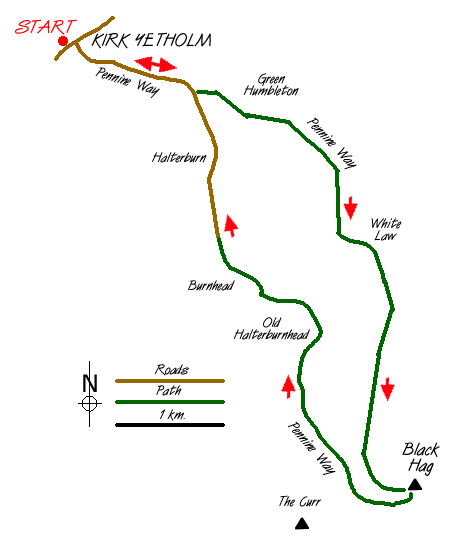
Route Map
Digital Maps - Copyright © 2011-2024. All rights reserved.
Sketch Map
Suggested Maps 

| Ordnance Survey Explorer OL16 | Sheet Map | 1:25k | BUY |
| Anquet OS Explorer OL16 | Digital Map | 1:25k | BUY |
| Ordnance Survey Landranger 74 | Sheet Map | 1:50k | BUY |
| Anquet OS Landranger 74 | Digital Map | 1:50k | BUY |
It is recommended you take a map. The preferred scale is 1:25k.
Start Point Details
Ordnance Survey Grid Ref NT827282
Latitude 55.547195 Longitude -2.27574
Postcode TD5 8PQ
what3words start loafing.corporate.laser
Walk description may contain detailed information on the start point for this walk.
Further Information
Northumberland
Walking in the Northumberland National Park covers a diverse area of landscape between the Tyne and the Scotland England border. The highest point within the National Park is the Cheviot and besides this famous hill there are many other notable summits. The valleys are also of interest to walkers, although some have restricted access. Northumberland Walking Guide
Walk grading - Learn how each walk is assessed and select a walk to suit your ability and experience by going to Walk Grading Details.
Messaging & Social Media
Message Walking Britain and follow the latest news.

Mountain Weather
Stay safe on the mountains with detailed weather forecasts - for iOS devices or for Android devices.