Stokesay Castle & View Edge
Shropshire Hills Walk
Region - Shropshire Hills
County/Area - Shropshire
Author - Lou Johnson
Length - 8.0 miles / 13 km Ascent - 860 feet / 261 metres
Time - 4 hours 50 minutes Grade - moderate
Maps 

| Ordnance Survey Explorer 203 | Sheet Map | 1:25k | BUY |
| Anquet OS Explorer 203 | Digital Map | 1:25k | BUY |
| Ordnance Survey Explorer 217 | Sheet Map | 1:25k | BUY |
| Anquet OS Explorer 217 | Digital Map | 1:25k | BUY |
| Ordnance Survey Landranger 137 | Sheet Map | 1:50k | BUY |
| Anquet OS Landranger 137 | Digital Map | 1:50k | BUY |
Walk Route Description
Click image to visit gallery of 3 images.
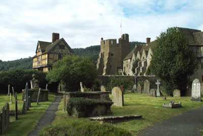
This walk provides an excellent introduction to rural Shropshire with the added benefit of providing the opportunity to visit a fine English Heritage property. The walk starts at the car park (grid ref. SO435815) opposite Stokesay Castle, well known for its picturesque looks. managed by English Heritage it is well worth a visit as is the fine 17th century church alongside.
After parking walk south along the lane past a pond on your right and take the footpath on your right. Cross the railway and head across a field climbing steadily to reach Stoke Wood. Follow the path through the wood in a westerly direction to reach Clapping Wicket. This section could be confusing but you need to take left hand stile and walk past the cottage before heading left towards View Wood.
The path follows the edge of the wood at first before merging with a track that enters the trees. This soon exits from the wood and you need to locate a sunken lane which heads back into the woods to emerge at a lane. Turn left for a short way to pick up a signed footpath on your right. Care must be taken not to miss the left turn after you have crossed three field. The path leads into a track by some farm buildings and this in turn joins a lane. Turn right and after a little less than a quarter of a mile take the signed footpath that leads left across fields.
Eventually you reach a lane although poor waymarking doesn't help route finding. Turn left (east) down this lane passing a number of cottages - the hamlet of Brandhill. At the last house there is a gate which leads to a path. Navigation on the next section can be tricky and almost impossible to describe but basically you need to follow the stream keeping it on your left as you walk through a mature wood. At times the path is a little overgrown but you soon reach Stonehouse Pools. A stile by a barn leads you out onto a lane.
Head northeast along the lane in the direction of the village of Onibury. the traffic is generally light and the countryside pleasant. Reaching the entrance to Stokesay Court turn left along the public lane to Aldon. Follow the lane for a short way to pick up the Shropshire Way as it heads up past Stokewood Cottage to Stokewood farm. Entering a wood at a stile and gate fork right downhill. This leads down to pastures where the path follows the railway. Go over the level crossing and follow the lane back to the starting point.
Other walks nearby
| Walk 2022 | Wenlock Edge & Aston Munslow | moderate | 7.8 miles |
| Walk 2395 | Mitchell's Fold & Bromlow Callow | easy/mod | 6.1 miles |
| Walk 3221 | High Vinnalls, Burrington, & Richard's Castle | mod/hard | 11.0 miles |
| Walk 2840 | High Vinnals & Richard's Castle | easy/mod | 6.0 miles |
| Walk 1321 | Caer Caradoc & Hope Bowder Hill | moderate | 9.0 miles |
| Walk 3048 | Caer Caradoc & The Lawley | moderate | 10.0 miles |
| Walk 2054 | Linley Hill & Beeches from Wentnor | easy/mod | 7.0 miles |
| Walk 3308 | Ragleth and the Long Mynd | mod/hard | 11.0 miles |
| Walk 3449 | Ragleth, the Long Mynd & Ratlinghope | hard | 18.0 miles |
| Walk 1374 | Lightspout Waterfall and Pole Bank | easy/mod | 5.8 miles |
Recommended Books & eBooks
Hillwalking in Shropshire
 Guidebook to 32 walking routes in Shropshire in the West Midlands. The routes range from 3 miles (5km) to 12 miles (19km), taking in highlights such as The Wrekin, Wenlock Edge, Long Mynd and Stiperstones, Castle Ring and Bury Ditches. Many routes start near delightful towns and villages including Church Stretton, Ludlow and Bishops Castle.
More information
Messaging & Social Media
Message Walking Britain and follow the latest news.

Mountain Weather
Stay safe on the mountains with detailed weather forecasts - for iOS devices or for Android devices.