Walk 1206 - printer friendly version
Chelmorton & Flagg from Taddington Walk
Author - Lou Johnson
Length - 6.0 miles / 9.8 km
Ascent - 840 feet / 255 metres
Grade - easy/mod
Start - OS grid reference SK141710
Lat 53.235848 + Long -1.7902098
Postcode SK17 9TU (approx. location only)
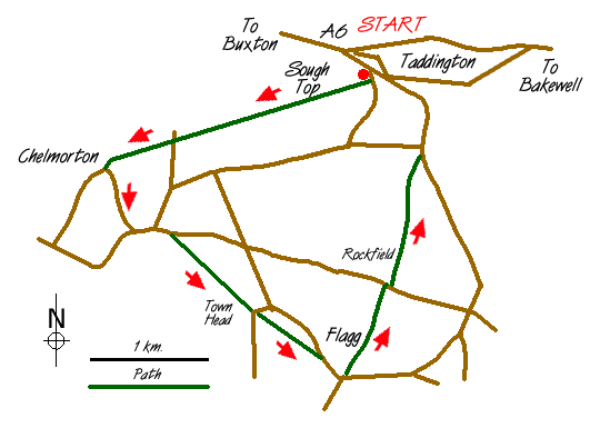
The White Peak is well known for its dales but the upland plateau into which these valleys were cut is less walked. This Peak District walk starts in the village of Taddington just off the main A6. The village offers plenty of on-street parking although do be considerate to residents and keep all accesses clear of obstruction. The most suitable point to park is close to the cross roads in the centre of the village (grid ref. SK141710) quite close to the church.
From here a narrow signed path climbs towards Sough Top crossing Slipperlow Lane shortly after leaving the village. The route to Chelmorton is straightforward and you cross numerous stiles in the many dry stone walls. Stay with the path to cross Sough Lane and Pillwell lane before following a wide rough track between stone walls that was once a mineral rake.
Crossing the southern flanks of Chelmorton Low you descend steeply into the village of Chelmorton. Joining a road go past the church and pub to a cross roads. Turn left here and take particular note of the narrow enclosures on your right with each plot of land carefully delineated by a stone wall. Evidence of former strip farming, this area is registered as of Historic importance by the National Park. The lane climbs a little to reach a junction. Turn left and stay on this lane going straight across at the next junction before taking the signed footpath on the right.
Crossing pastures you descend towards Town Head farm. Exit into a lane and almost opposite pick up another path that runs parallel to the main village road to exit close to the centre of Flagg. Continue southwards along the lane as far as the old school. Turn left at the footpath sign, over the stile in the wall following the waymarked route round the farm until the fields at the back are reached. The route is clear and you reach Flagg Lane. Turn right and then almost immediately left onto a path that leads past Rockfield House. Not far past the house look out for a stile on your right - there is no footpath sign. Cross this and the onward path is fairly clear as you climb steadily through the remains of mining activity to reach a lane. Follow this north down into Taddington to the starting point.
Messaging & Social Media
Message Walking Britain and follow the latest news.

Mountain Weather
Stay safe on the mountains with detailed weather forecasts - for iOS devices or for Android devices.