Dow Crag & the Old Man of Coniston from Coniston
Lake District Walk
Nat Park - Lake District - Lake District Southern Fells
Wainwrights - Dow Crag, Coniston Old Man
County/Area - Cumbria
Author - Lou Johnson
Length - 8.5 miles / 13.8 km Ascent - 3040 feet / 921 metres
Time - 7 hours 20 minutes Grade - mod/hard
Maps 

| Ordnance Survey Explorer OL6 | Sheet Map | 1:25k | BUY |
| Anquet OS Explorer OL6 | Digital Map | 1:25k | BUY |
| Ordnance Survey Landranger 90 | Sheet Map | 1:50k | BUY |
| Anquet OS Landranger 90 | Digital Map | 1:50k | BUY |
Walk Route Description
Click image to visit gallery of 9 images.
This is a Lake District walk of some quality combing one of Lakeland's finest summits with one of its most popular. The walk description starts in Coniston village where there is ample parking except at busy times.
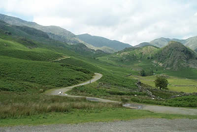
From Coniston Village take the lane up past the Sun Inn. This soon narrows and begins a steep climb out of the village with improving views across the Coniston Fells. The metalled lane ends at a gate (grid ref. SD289970) which provides access to the open fell and the Walna Scar Road. Follow the Walna Scar Road, a wide track, as it heads roughly west across open country. Progress is relatively fast on an easy rising gradient.
Stay with the Walna Scar Road as you skirt the southern slopes of the Old Man of Coniston to cross Torver Beck. The going gets steeper as you climb onto the ridge between White Maiden and Brown Pike. Ahead lies Dunnerdale. Just over the crest take a clear path right. This leads easily to the first summit of this round - Brown Pike. Continue along the ridge to Buck Pike from where there is a superb view of Dow Crag ahead. In poor visibility some care is needed on the next section. If in doubt trend left (west) as there are some nasty gullies and steep crags to your right! Nearing the summit you should encounter a ruined wall and this acts as a good guide for the final stretch to the top.
The summit of Dow Crag is superb offering a chance to practice your scrambling skills. With an almost sheer drop down to Goat's Water far below and a panorama including some of the highest fells in the Lake District it is worth spending some time here. Descend north to pick up a cairned path that leads you down to Goat's Hawse. From here there is some 500 feet of ascent to reach the summit of the Old Man of Coniston. For peak baggers a short diversion to the summit of Brim Fell will add another top to your list!
Only rarely are you likely to have the summit of the Old man to yourself. It is a popular target for many visitors and does offer some superb views in all directions especially in the northern sector. The descent path drops off towards the east. The first section in particular has suffered badly from erosion and is not very pleasant. However the going improves and reaching Low Water you have completed the worst section of your downhill journey.
This area saw extensive quarrying and mining and the landscape is consequently scarred. As you descend you pass through some of the old workings with ruined buildings and equipment scattered on either side. There are many paths and tracks and these increase in number as you descend. Reaching a major junction (grid ref. NY284981) turn right along a wide track that runs almost level due south to reach the gate on the Walna Scar Road where you first entered the open fell. All that remains is to follow the lane back down to Coniston village enjoying the retrospective view of the Coniston Fells.
Other walks nearby
| Walk 1911 | Coniston's Magnificent Seven | hard | 13.0 miles |
| Walk 3110 | The Old Man of Coniston & Dow Crag from Torver | mod/hard | 8.5 miles |
| Walk 2033 | Tilberthwaite & Wetherlam | moderate | 5.0 miles |
| Walk 3320 | Grizedale Tarn circular | easy | 2.5 miles |
| Walk 3410 | Latterbarrow from Hawkshead | easy | 4.0 miles |
| Walk 3508 | The Crinkle Crags from Wrynose Pass | easy/mod | 5.0 miles |
| Walk 1134 | Wetherlam and The Carrs | mod/hard | 10.8 miles |
| Walk 2270 | Tilberthwaite and Holme Fell Little Langdale | easy/mod | 5.5 miles |
| Walk 3638 | Satterthwaite Bridge Circular | easy | 3.2 miles |
| Walk 1058 | Beacon Fell & Beacon Tarn Circular | easy/mod | 4.0 miles |
Recommended Books & eBooks
Great Mountain Days in the Lake District
 An inspirational guidebook to 50 challenging walks on the high fells of the Lake District. The graded circular routes, between 4 and 14 miles in length, cover classic Lakeland summits like Fairfield, Scafell Pike, Great Gable and Blencathra, to the lesser-known High Spy, King's How and Brund Fell.
More information
Walking the Lake District Fells - Buttermere
 Part of the Walking the Lake District Fells series, this guidebook covers a wide range of routes to 32 Lakeland summits that can be climbed from the Buttermere, Lorton and Newlands valleys, with highlights including Haystacks, High Stile, Grasmoor and the fells of the Coledale Round. Suggestions for longer ridge routes are also included.
More information
Messaging & Social Media
Message Walking Britain and follow the latest news.

Mountain Weather
Stay safe on the mountains with detailed weather forecasts - for iOS devices or for Android devices.