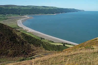
Selworthy Beacon & North Hill from Bossington
Exmoor Walk
Nat Park - Exmoor
County/Area - Somerset
Author - Lou Johnson
Length - 8.5 miles / 13.8 km Ascent - 1225 feet / 371 metres
Time - 5 hours 30 minutes Grade - moderate
Maps 

| Ordnance Survey Explorer OL9 | Sheet Map | 1:25k | BUY |
| Anquet OS Explorer OL9 | Digital Map | 1:25k | BUY |
| Ordnance Survey Landranger 181 | Sheet Map | 1:50k | BUY |
| Anquet OS Landranger 181 | Digital Map | 1:50k | BUY |
Walk Route Description
Click image to visit gallery of 6 images.
This walk includes moors, woodland and coast - the three essential ingredients of Exmoor. In addition the route visits three picturesque villages and includes a high level section of the South West Coast path so can never be criticised for lack of interest.
The start is in the National Trust car park (Grid ref. SS898479) in the village of Bossington, which is worth looking round either before or after the walk. Leave the car park at the north-eastern end to cross a bridge. Continue by following the signed footpath towards Hurlstone Point. Just short of the Point you meet the South West Coast Path, which you follow in the direction of Minehead climbing steeply onto Bossington Hill. It is worth making a slight detour to the summit as it provides a superb view across Porlock Bay.
Return to the South West Coast Path and follow this towards Selworthy Beacon making another short detour to reach the summit. The view from here is superb with views across to the high moors of Exmoor and Dunkery Beacon. Rejoin the South West Coast Path and follow this as it meanders across rolling countryside about eight hundred feet above the sea some half a mile to your left.
Reaching the flanks of North Hill turn south (Grid ref. 943477) along a narrow path to reach the summit, which is marked as a viewpoint on OS maps. Leave the summit along a broad track in a westerly direction. This track runs parallel to and a little way north of the road crossing this area of open moorland. Stay with this track until you reach the road (Grid ref. 924479) just before the final climb to the summit to Selworthy Beacon. Cross the road and head south east and take the first distinct path/track on your right. This descends into the valley eventually entering woodland.
The track exits onto a road at Selworthy. To your left a short way up the lane is the whitewashed Selworthy church, which is worth a visit as it has commanding views south to the moors. To your right are the thatched rooves of the cottages built for the retired workers of the Holnicote Estate. Go through the gate and walk through the green that forms the centrepiece of this attractive village. Reaching the lane turn right and follow this for a short way to take a signed footpath on your right to Allerford where you continue into the village to cross the famous packhorse bridge.
After crossing the bridge turn right and continue along the road in the direction of Bossington. Turn right down the lane to Stokes Farm picking up a footpath that leads through pleasant woodland to return you to the starting point.
Other walks nearby
| Walk 3725 | Selworthy Beacon from Selworthy | easy/mod | 5.5 miles |
| Walk 1750 | Dunkery Beacon (short ascent) | easy/mod | 2.5 miles |
| Walk 2211 | Minehead to Dunster | easy | 5.0 miles |
| Walk 1220 | Dunkery Beacon | moderate | 8.0 miles |
| Walk 1262 | Watersmeet & Foreland Point | mod/hard | 10.5 miles |
| Walk 1263 | The Doone Valley | moderate | 8.5 miles |
| Walk 1222 | Winsford Hill & the Allotment | moderate | 6.0 miles |
| Walk 2451 | Withypool & Barle Valley | easy/mod | 6.0 miles |
| Walk 3729 | Foreland Point | moderate | 5.0 miles |
| Walk 3386 | Barle Valley & Cow Castle from Simonsbath | easy/mod | 6.4 miles |
Recommended Books & eBooks
South West Coast Path Map Booklet - Minehead to St Ives
 Map of the northern section of the 630 mile (1014km) South West Coast Path National Trail. Covers the trail from Minehead to St Ives along the north Devon and Cornish coastline. This convenient and compact booklet of Ordnance Survey 1:25,000 maps shows the route, providing all of the mapping you need to walk the trail in either direction.
More information
South West Coast Path Map Booklet - St Ives to Plymouth
 Map of part of the southern section of the 630 mile (1014km) South West Coast Path National Trail. Covers the trail from St Ives to Plymouth along the west Cornwall and Devon coastline. This convenient and compact booklet of Ordnance Survey 1:25,000 maps shows the route, providing all of the mapping you need to walk the trail in either direction.
More information
Messaging & Social Media
Message Walking Britain and follow the latest news.

Mountain Weather
Stay safe on the mountains with detailed weather forecasts - for iOS devices or for Android devices.