Arthur's Pike & Loadpot Hill from Martindale
Lake District Walk
Nat Park - Lake District - Lake District Far Eastern Fells
Wainwrights - Arthur's Pike, Loadpot Hill
County/Area - Cumbria
Author - Lou Johnson
Length - 9.0 miles / 14.6 km Ascent - 2080 feet / 630 metres
Time - 6 hours 40 minutes Grade - moderate
Maps 

| Ordnance Survey Explorer OL5 | Sheet Map | 1:25k | BUY |
| Anquet OS Explorer OL5 | Digital Map | 1:25k | BUY |
| Ordnance Survey Landranger 90 | Sheet Map | 1:50k | BUY |
| Anquet OS Landranger 90 | Digital Map | 1:50k | BUY |
Walk Route Description
Click image to visit gallery of 9 images.
A Lake District circular walk of contrasts exploring the northernmost section of the High Street range. The first section is pleasant low level walking with limited views across Ullswater and to the crags of Bonscale Pike. The route changes in character as you follow the High Street ridge before dropping down for a pleasant walk through Fusedale.
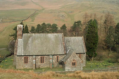
The walk starts at the new Martindale Church (Grid ref. NY435191) where limited parking is available and it is worth remembering that on busy days you may have to seek out another spot to park. From the parking area head south keeping the church on your left crossing an area of rough pasture to locate a clear track that descends northeast into Howtown. Stay on this track passing Mellguards where the route swings north.
There now follows a lengthy section keeping the intake wall on your left to reach Auterstone Wood. En-route you will have passed the dramatic ravine that contains Swarthbeck Gill, which drains much of the high ground used for the middle section of the walk. After Auterstone Wood the path leaves the intake wall and heads across open fellside climbing steadily to reach a junction of paths (Grid ref. 473220). Turn sharp right here and continue climbing southwestwards to reach a rocky knoll marked as White Knotts on the OS 1:25000 map. This makes an ideal place to stop and take in the view.
Leaving White Knotts take the narrow path that follows the 'edge' heading southwest along the top of the crags. To your right there are superb views across Ullswater to the high fells of the Helvellyn range. After about a mile you will reach a large cairn. This offers a grand panorama over almost the whole of Ullswater. From this cairn follow a feint path southeast to gain the cairn on the summit of Arthur's Pike. Care is needed to ensure you now locate the right path and looking south you will see a path junction (Grid ref. 461204). Take the broader path heading south. This will lead you onto the old Roman Road.
Follow this in the same direction towards the round shape of Loadpot Hill. The main path contours around the western flank and you should leave this continuing straight on to reach the summit of Loadpot Hill. The view is not spectacular but it does mean you have conquered another 'Wainwright'. Head off the summit in a southerly direction to rejoin the main path close to the ruins of the chimney marked on maps.
On your right (Grid ref. 455173) you will notice a feint path heading west down the northern side of Groove Gill. This path is not marked on maps. A short way after leaving the Roman Road the path fades to nothing and you need to descend over grass keeping the gill on your left. After a few minutes of descent you will notice a path crossing the Gill and you should use this to gain the southern bank. Continue your descent and you will soon join a grassy path for the remainder of the descent into Fusedale.
Continue on the main valley path, passing a derelict barn, to reach the track you used for the first section of the walk. Turn left and after a gentle ascent you will arrive back at the start.
Other walks nearby
| Walk 2039 | Gowbarrow Fell circular | moderate | 3.5 miles |
| Walk 1230 | Birks & Arnison Crag | moderate | 5.5 miles |
| Walk 1520 | Helvellyn & Fairfield Horseshoe from Patterdale | very hard | 13.0 miles |
| Walk 2047 | Place Fell | moderate | 7.5 miles |
| Walk 2425 | Boredale Circular from Patterdale | mod/hard | 11.5 miles |
| Walk 3670 | Angle Tarn and Hayeswater | moderate | 8.3 miles |
| Walk 1156 | Helvellyn via Striding Edge | hard | 9.5 miles |
| Walk 1235 | Red Tarn & Grisedale | moderate | 7.0 miles |
| Walk 1710 | Glenridding, St. Sunday Crag & Helvellyn | hard | 11.5 miles |
| Walk 3232 | Glenridding Dodd & Sheffield Pike | easy/mod | 4.5 miles |
Recommended Books & eBooks
Walking the Lake District Fells - Buttermere
 Part of the Walking the Lake District Fells series, this guidebook covers a wide range of routes to 32 Lakeland summits that can be climbed from the Buttermere, Lorton and Newlands valleys, with highlights including Haystacks, High Stile, Grasmoor and the fells of the Coledale Round. Suggestions for longer ridge routes are also included.
More information
Great Mountain Days in the Lake District
 An inspirational guidebook to 50 challenging walks on the high fells of the Lake District. The graded circular routes, between 4 and 14 miles in length, cover classic Lakeland summits like Fairfield, Scafell Pike, Great Gable and Blencathra, to the lesser-known High Spy, King's How and Brund Fell.
More information
Messaging & Social Media
Message Walking Britain and follow the latest news.

Mountain Weather
Stay safe on the mountains with detailed weather forecasts - for iOS devices or for Android devices.