Lonscale Fell & Latrigg from Underscar
Lake District Walk
Nat Park - Lake District - Lake District Northern Fells
Wainwrights - Latrigg, Lonscale Fell
County/Area - Cumbria
Author - Lou Johnson
Length - 7.5 miles / 12.2 km Ascent - 2150 feet / 652 metres
Time - 5 hours 50 minutes Grade - moderate
Maps 

| Ordnance Survey Explorer OL4 | Sheet Map | 1:25k | BUY |
| Anquet OS Explorer OL4 | Digital Map | 1:25k | BUY |
| Ordnance Survey Landranger 90 | Sheet Map | 1:50k | BUY |
| Anquet OS Landranger 90 | Digital Map | 1:50k | BUY |
Walk Route Description
Click image to visit gallery of 6 images.
Many fells are ignored because there are higher and seemingly grander fells close by. This Lake District walk combines one of these, Lonscale Fell, with a very popular lower fell, namely Latrigg. I have always wanted to ascend both of these 'Wainwrights' and to walk them together seemed a good idea.
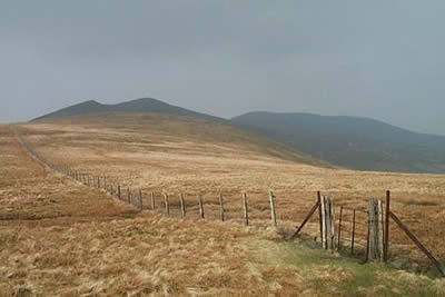
The start is the car park at the end of the 'Underscar Lane' (Grid ref. NY281253). Generally there is ample space here but on busy days expect to park further down the lane. After parking go through the gate and follow the 'motorway' heading for Skiddaw. The path passes the Howell Monument and climbs steadily with the fence on your left. Crossing to the other side of the fence the gradient begins to ease.
Instead of following the main path stay close to the fence and follow this into a valley containing Whit Beck. The path despite little use is easy to follow and you soon reach a broad col and a fence. Go through the gate and turn right. Head east towards the rounded summit of Lonscale Fell, which turns out to be rather disappointing. However a few hundred metres east of the highest point lies the East Peak. This pointed secondary summit is easily seen from other fells. Here the views are much improved from the lofty, rocky perch with Glenderaterra Beck far below and the slopes of Blencathra beyond.
After enjoying the delights of Lonscale Fell, return to the fence (Grid ref. 284272) and follow this heading north and descending steeply over grass. There is a path on both sides and they lead you over the quaintly named Burnt Horse ridge to reach the Cumbria Way (Grid ref. 294287). Turn right and follow this superb path as it follows a high level route across the eastern flank of Lonscale Fell with Glenderaterra Beck below on your left. This path leads without any further need for description back to the start of the walk.
It seems a pity to return to the car just yet and as Latrigg provides some superb views over Keswick and Derwentwater why not make a quick circuit on to its summit. The route is obvious climbing south from the lane on grass with the fence on your left. Reaching a clear path turn right and this leads to the summit and the best viewpoints in a few hundred metres. After taking in the view return is made using the clear path that contours across the western slopes of Latrigg to lead you back to the lane and the start of the walk.
Other walks nearby
| Walk 3029 | Derwentwater & Walla Crag | easy/mod | 6.5 miles |
| Walk 3037 | High Seat & Bleaberry Fell from Keswick | moderate | 9.0 miles |
| Walk 2321 | Shores of Derwentwater from Keswick | easy | 3.5 miles |
| Walk 2587 | Castlerigg Stone Circle & St John's in the Vale | easy/mod | 8.5 miles |
| Walk 1356 | Walla Crag from Great Wood | easy/mod | 4.5 miles |
| Walk 2036 | Cat Bells from Gutherscale | easy/mod | 4.0 miles |
| Walk 3525 | Cat Bells (Route 2) | easy/mod | 4.0 miles |
| Walk 3119 | The Newlands Horseshoe - Catbells, Dale Head & Hindscarth | mod/hard | 12.0 miles |
| Walk 1120 | Grisedale Pike & Crag Hill fro Braithwaite | mod/hard | 8.5 miles |
| Walk 2038 | Tower Ridge on Eel Crag returning via Sail & Barrow | hard | 6.3 miles |
Recommended Books & eBooks
Walking the Lake District Fells - Keswick
 Part of the Walking the Lake District Fells series, this guidebook covers a wide range of routes to 30 Lakeland summits that can be climbed from Keswick, Whinlatter, Bassenthwaite, Caldbeck, Mungrisdale and Threlkeld, with highlights including Skiddaw and Blencathra. Includes suggestions for longer ridge routes.
More information
Lake District: Low Level and Lake Walks
 This guidebook describes 30 of the best low-level walks in the Lake District. From delightful wooded glades and sparkling tarns, to waterfalls and glacier-carved valleys towered over by craggy mountains. The walks described aim to seek out the best walking that the lower areas of the Lake District have to offer.
More information
Messaging & Social Media
Message Walking Britain and follow the latest news.

Mountain Weather
Stay safe on the mountains with detailed weather forecasts - for iOS devices or for Android devices.