Helvellyn & Raise from Swirls
Lake District Walk
Nat Park - Lake District - Lake District Eastern Fells
Wainwrights - Helvellyn, Raise, White Side
County/Area - Cumbria
Author - Lou Johnson
Length - 7.0 miles / 11.4 km Ascent - 3140 feet / 952 metres
Time - 6 hours 40 minutes Grade - mod/hard
Maps 

| Ordnance Survey Explorer OL5 | Sheet Map | 1:25k | BUY |
| Anquet OS Explorer OL5 | Digital Map | 1:25k | BUY |
| Ordnance Survey Landranger 90 | Sheet Map | 1:50k | BUY |
| Anquet OS Landranger 90 | Digital Map | 1:50k | BUY |
Walk Route Description
Click image to visit gallery of 10 images.
Helvellyn, England's third highest mountain, is a popular mountain. This Lake District walk ascends from Thirlmere and then heads north along the ridge to use a less frequented route for the descent. The day this walk was researched was extremely windy and, despite blue skies, was not for the feint-hearted. With this in mind it is important that any ascent is treated as a serious walk and suitable backup equipment taken in case the weather worsens.
The start is the car park at Swirls ( Grid ref. NY316168 ) is on the A591 Windermere to Keswick road. Leave the car park and cross over the footbridge to the left (north) bank of the gill. Continue to follow the left bank until a signpost to Helvellyn directs you over another footbridge to the right bank. Now head up the restored path towards Brown Cove Crags. During this ascent all the views are behind you so you always have an excuse to stop and catch your breath.
The path roughens and steepens and swings right to skirt the top of Brown Cove Crags but soon levels as you approach the summit plateau. It is important to remember these crags are dangerous and if in doubt trend right rather than left. However Helvellyn's summit is soon reached and you will probably find that you are not alone! Besides the trig point there is a sizeable shelter.
To continue the route retrace your steps for about 400 metres before bearing right along a clear path to the summit of Helvellyn Lower Man. There are excellent views of Catstye Cam from here together with the route as far ahead as Raise. Descending north quite steeply you reach a col from where there is an easy ascent to the summit of Whiteside.
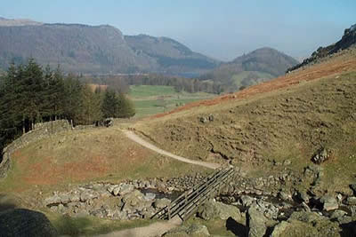
Another descent and ascent again in a northerly direction leads you to the summit of Raise where there are good views ahead to the Dodds. All the climbing is over and you descend to Sticks Pass, which is a broad Col with a cairn. Turn left here and keeping to the north of Sticks Gill follow the path down towards Legburthwaite. This path is a joy with little or no erosion and will the benefit of a great view ahead.
Reaching a sheepfold you have another excuse for a rest as the view is superlative. The descent on grass becomes steep as you drop down towards Stybeck Farm. Reaching the intake wall you turn left and follow this pleasant undulating path back to the start.
Other walks nearby
| Walk 3132 | High Tove & Blea Tarn | moderate | 7.6 miles |
| Walk 2019 | Raven Crag, the Benn & Shoulthwaite Gill near Thirlmere | easy/mod | 4.0 miles |
| Walk 2032 | Great How, a short ascent above Thirlmere | easy | 2.0 miles |
| Walk 1158 | High Rigg | easy | 5.5 miles |
| Walk 2005 | High Rigg & Legburthwaite | easy | 5.5 miles |
| Walk 2049 | Calfhow Pike & the Dodds from Legburthwaite | moderate | 7.5 miles |
| Walk 2524 | Thirlmere Circular | easy | 5.0 miles |
| Walk 1229 | Helvellyn & Dollywaggon Pike from Wythburn | moderate | 8.0 miles |
| Walk 2525 | Standing Crag & Dock Tarn from Watendlath | moderate | 7.0 miles |
| Walk 2526 | Standing Crag, Ullscarf & Borrowdale | mod/hard | 10.0 miles |
Recommended Books & eBooks
Walking the Lake District Fells - Wasdale
 Part of the Walking the Lake District Fells series, this guidebook covers a wide range of routes to 25 Lakeland summits that can be climbed from the Wasdale, Eskdale and Ennerdale valleys, with highlights including Scafell Pike, Great Gable and Pillar. Suggestions for longer ridge routes are also included.
More information
Walking the Lake District Fells - Mardale and the Far East
 Part of the Walking the Lake District Fells series, this guidebook covers a wide range of routes to 36 Lakeland summits that can be climbed from the Ullswater, Haweswater, Troutbeck, Kentmere and Longsleddale valleys, with highlights including High Street, Place Fell and the Kentmere fells. Suggestions for longer ridge routes are also included.
More information
Messaging & Social Media
Message Walking Britain and follow the latest news.

Mountain Weather
Stay safe on the mountains with detailed weather forecasts - for iOS devices or for Android devices.