Great Whernside from Kettlewell
Yorkshire Dales Walk
Nat Park - Yorkshire Dales - Upper Wharfedale
County/Area - North Yorkshire
Author - Lou Johnson
Length - 8.0 miles / 13 km Ascent - 1830 feet / 555 metres
Time - 5 hours 50 minutes Grade - moderate
Maps 

| Ordnance Survey Explorer OL30 | Sheet Map | 1:25k | BUY |
| Anquet OS Explorer OL30 | Digital Map | 1:25k | BUY |
| Ordnance Survey Landranger 98 | Sheet Map | 1:50k | BUY |
| Anquet OS Landranger 98 | Digital Map | 1:50k | BUY |
Walk Route Description
Click image to visit gallery of 12 images.
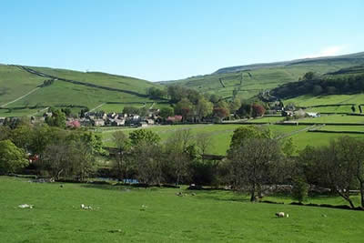
The first point to make is that this is an ascent of Great Whernside and is not to be confused with Whernside near Ribblehead. Although not a member of Yorkshire's 'Big Three', it rises higher than Pen-y-ghent and offers an interesting route. The start is the village of Kettlewell in Wharfedale where there is a large pay and display car park (grid ref. SD968723) and some roadside parking.
To start this Yorkshire Dales walk head into the village along the main road to the bridge over Dowber Gill Beck. Do not cross the bridge but turn right and follow the lane west keeping the beck on your left. Continue past cottages and stay on the lane as it swings north to locate a signed footpath (grid ref 975726) leading to Providence Pot. This path follows the beck along a steep sided valley climbing steadily to reach Providence Pot, which is covered by a concrete cap and manhole cover! At this point turn back to face Kettlewell and you will see a clear path climbing more steeply out of the valley. Take this and continue to Hag Dyke Farm - now used as a Scout Centre.
From Hag Dyke the onward route is obvious in clear weather with the crags of Great Whernside visible across the fellside. The path leaves Hag Dyke and immediately climbs a rocky escarpment to reach a group of small cairns. From here the path is marked by posts as it crosses a flatter area that could be very squelchy area after rain before climbing a second escapement to reach the summit. In good weather the views are superb and include Wharfedale, Buckden Pike, Cross Fell in the Pennines, the Lakeland fells, the 'Big Three', Pendle Hill and Simon's Seat.
From the summit head north along a clear path that follows the Yorkshire Dales National Park boundary. Ignore secondary paths descending left instead staying on the ridge to reach a stile (grid ref. 998752). Cross the stile and descend along the wall following a clear path. This leads without problem to reach the road (grid ref. 986757) at Little Hunters Sleet. Cross the road and follow the track heading west. This leads into Starbotton Lane and a finger post (grid ref. 970753). Turn left down the track (Top Mere Road) to descend gently for just under two miles into Wharfedale and Kettlewell.
Other walks nearby
| Walk 2332 | Mastilles Lane & Bordley from Kilnsey | easy/mod | 6.8 miles |
| Walk 3301 | Conistone to Grassington via the Dib | easy | 5.0 miles |
| Walk 3262 | Copplestone Gate and Conistone Pie from Conistone | easy/mod | 7.0 miles |
| Walk 2423 | Capplestone Gate & Conistone Pie | easy/mod | 6.8 miles |
| Walk 1254 | Yockenthwaite & Hubberholme | moderate | 8.0 miles |
| Walk 1281 | Buckden Pike | moderate | 10.5 miles |
| Walk 2132 | Buckden Pike and Hubberholme | moderate | 8.4 miles |
| Walk 1926 | Pen-y-ghent & Littondale | hard | 16.0 miles |
| Walk 1145 | Grassington, Mastilles Lane & Conistone Dib | moderate | 11.3 miles |
| Walk 1645 | Grassington, Mastilles Lane & Conistone Dib | moderate | 12.0 miles |
Recommended Books & eBooks
Walking in the Yorkshire Dales: North and East
 This guidebook contains 43 circular day walks in the north and east Yorkshire Dales. It explores the dales, hills and moors between Kirkby Stephen and Pateley Bridge. Walking ranges from gentle 3 mile strolls to more strenuous day-long rambles across the Howgills, Wensleydale, Swaledale, Nidderdale, Mallerstang and Coverdale.
More information
Walking in the Yorkshire Dales: South and West
 Part of a two-book set, this guidebook describes 44 walks in the southern and western Yorkshire Dales, including the famous 23 mile Three Peaks circuit over Pen-y-Ghent, Whernside and Ingleborough. The other, mostly circular routes of 3½ to 13 miles cover the scenic region between Sedbergh, Kirkby Lonsdale, Settle, Skipton and Grassington.
More information
Messaging & Social Media
Message Walking Britain and follow the latest news.

Mountain Weather
Stay safe on the mountains with detailed weather forecasts - for iOS devices or for Android devices.